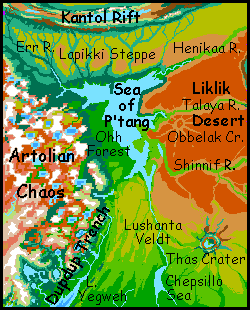
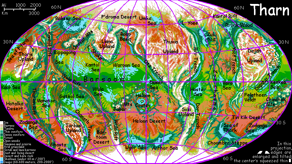
Sea of P'tang
by Chris Wayan, 2005-6
Map, Tharn's homepage, Peoples of Tharn, Regional tours, Geology and Evolution, gazetteer, terms explained. More worlds? Planetocopia!
INTRODUCTION
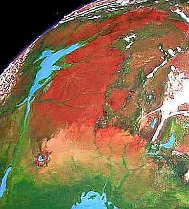
The Sea of P'tang is a triangular bedlake 1500 km long (900 mi) west of the Liklik Desert and east of the Artolian Chaos. The straighter western shore is a broad open wood, Ohhh Forest. The east is broken with islands, bays, and satellite lakes; but here the woods end abruptly in cliffs rising to a dry plateau: the Liklik Desert, largest in the northern hemisphere.
We'll circle the sea clockwise, starting with:
OHHH FOREST
The greenest shore of P'tang is the Ohhh Forest, on its west. It's bigger than Britain: around 720 km (450 mi) north to south, and stretching from the P'tang shores to the rugged Alpine basins of the Artolian Chaos some 500 km inland (300 mi).
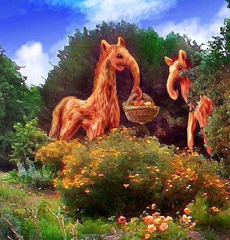
Ohhh (a deep, croaking groan with a dropping pitch) was named by, and is the home of, elaffes, a huge, slow, giraffish people of the northern woods. They're strict herbivores who pick leaves, buds, fruit and nuts from trees. They've bred several native fruit and nut trees, and introduced half a dozen others from their twin homelands to the west: Rronk Wood and Yoof Trench.
The result is that Ohhh Forest is really one vast tree-farm. It doesn't look like it, simply because elaffes never plant monocropped orchards. They don't need to plant in rows, or breed dwarf trees low enough to pick easily. They can reach 7 meters up without rearing, and a tall individual can fruit-pick up to 11 m (36') and still have its hind feet on the ground!
Though dominated by elaffes, Ohhh Forest is warm enough for a large minority of mops and even a few lobbras, especially around the opener southern fringes. In the northwest, a long wooded corridor, the Err? River, leads 2000 km to the elaffe heartland, Rronk Wood. Due west, though, the wooded plain heaves upward into ridges, ever taller and sharper, until the forest frays into jagged alps, called:
THE ARTOLIAN CHAOS
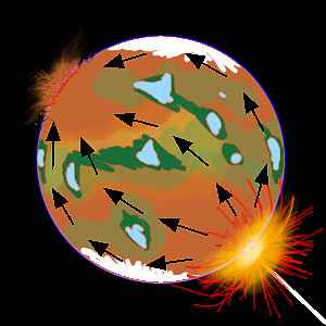
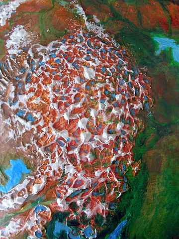
Four hundred million years ago, on the far side of Tharn, the huge Heloon impact dug out a monstrous crater and caused a planetary firestorm. It was so big, the whole globe rang--and tore. Just west of Ohhh Forest, exactly opposite the crater, there's a huge, chaotic upland of snowy peaks and lake-filled basins, formed at impact by shock waves converging round the world, as if Tharn were a great lens.
Even Earth's busiest volcanoes take ten thousand years to reach Andean heights. The Artolian Chaos rose in ten minutes! And rose is too mild a word: leapt into low space and fell again in a rain of red-hot mountains. Once far higher than the Himalaya, they've eroded down to merely Andean size. But even today, the strangeness of the land is visible from space--Artol has a cellular look, like the standing waves in a vibrating pan of water.
Such chaoses are known in our solar system too. Mercury has a violently torn-up region opposite its huge Caloris Basin.
And Artol got off easy. Compare the locations of Mars's two great impact basins (Hellas and Argyre) and volcanic uplands (Tharsis and Elysium). They're not quite paired opposites, but close enough to be suggestive (if you postulate some hot-spot drift toward the equator, make that very suggestive. Continents on Earth do feel centrifugal force and drift toward the tropics--but surely the Martian bulges aren't drifting like Terran continental plates... are they? The magma plumes creating them may be denser than the surrounding rock, so they were bent equatorward by centrifugal force. Or the two vast holes, lighter than the surrounding highlands, could be wrestling the whole planet so they creep toward the poles--again with no moving plates.) Now Mars has a cool crust, hard for volcanic vents to melt or burst through, so once they did, the volcanoes grew and grew.
Sorry, I do get carried away. Ooh, impacts go BOOM! Go boom TWICE! Speculation is such sweet sorrow...
Let's get back to firmer ground--what a laugh! In either sense. Tharn's a total speculation, AND of all its ground, Artol has to be the least firm. Chaos! Though in fact, all that melted mess held together, once it cooled, fairly well. After the temporary shock, it seems like Tharn's mantle just went about its business serenely. Magma went on circulating in existing convection loops--the same old trenches, rifts and volcanoes. Surprising; but Artol is near several active regions that could relieve any pressure.
So the chaos formed a great blunt tongue sticking out from Dejah Upland--but not a constantly active, volcanic upland like some continents on Earth or a Martian volcanic bulge. There are indeed volcanoes--at least three white cones taller than Denali are visible even from orbit. But compared to the great fiery boils on Mars, Artol is quiet--an Iceland at most.
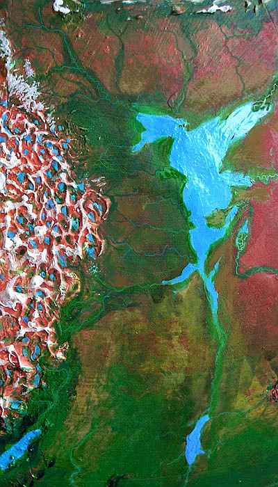
The east edge of the chaos, near the Sea of P'tang, is greener; rain gets in, accelerating erosion, and the random basins have linked into sane drainage systems and gnawed the peaks down to Alpine scale, low enough for life to creep in. Trees ring the lakes and line the rivers. But further west, over a dozen waves of jagged peaks, the air's thin and wrung quite dry. Here the catastrophe's never healed: the peaks tower, the treeless basins have no outlets, and the few lakes are brackish and ringed in cold saltmarsh or rusty mudflats. Even mamooks just visit.
NORTH
The north shore of P'tang is a mild maritime strip; but only 100 km inland, the trees thin to prairie. This is the Lapikki Steppe, a dry grassy plain running 400 km north and 2000 east-west. To the east and southeast the grass fades into the hotter and even drier Liklik Desert. Most of this wide, windy prairie is sparsely populated; most locals are lobbras, a bit more cold-tolerant than other savanna-species like centahs and veltaurs. The only year-round water and farmable oases are the valleys of shallow, gravelly rivers ("a mile wide and an inch deep" as Terrans say of the similar Platte River) rising in the Kantol Rift Zone and winding south over the plain. The largest such oasis is in the far east: the Henikaa River. The Henikaa flows 2000 km from northern Thoris Upland west to Henikaa Bay, the northeastern arm of the Sea of P'tang. The lower Henikaa Canyon widens to a floodplain 50-100 km wide, farmed by flyotes and lobbras. A temperate Nile!
The next largest (and historically the most important) is the Err? River in the northwest, some 600 km long. "Err?" is an attempt to transliterate the native elaffe name--it's a deep, creaking yawn with a rising pitch. Elaffe settlers from Rronk Forest, far to the west, found the Err? Valley the only migration corridor to the P'tang Sea. The western forks of the Err? rise in the icy peaks fringing huge Dejah Upland; they collect in Err? Valley and flow southeast to the Sea of P'tang.
The East Err? rises in the ridges of the Kantol Rift, just south of Lake Amhor (though Amhor itself doesn't feed the Err?; deep in the rift, the lake has no outlet). The Kantol ridges run east-west here; their cold north slopes are thin evergreen forest; the warmer south-facing slopes, mixed forest opening to meadows on the lower slopes. Most of the locals are shaggy-feathered people called mops though there are a few elaffes. The East Err?'s tributaries flow south across the Lapikki Steppe to join the West Err? fork only 100 km from the shore of triangular Err? Bay on the Sea of P'tang.
The similar Lapikki River crosses the steppe 400 km east of the East Err?, pouring into the east end of Err? Bay. Only lobbras and mops farm the Lapikki Valley; elaffes find it too dry.
THE LIKLIK DESERT
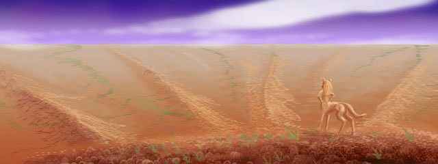
West of the Sea of P'tang lies the Liklik Desert. Liklik is huge--a red plain 2000 by 1200 km across (1250 by 750 mi), extending nearly to the shore of the Sea of P'tang. At this latitude, cool dry air blows west off Thoris Upland's icy heights and across the desert to the sea; so most storms off P'tang blow further west, onto Ohhh Forest. As a result, Liklik is the largest, harshest desert in the northern hemisphere--if, of course, you ignore the uplands themselves.
There are oases; I've already mentioned the great Henikaa Valley. But to the south, it's 400 km of dry red plains before the next landmark: Talaya Canyon.
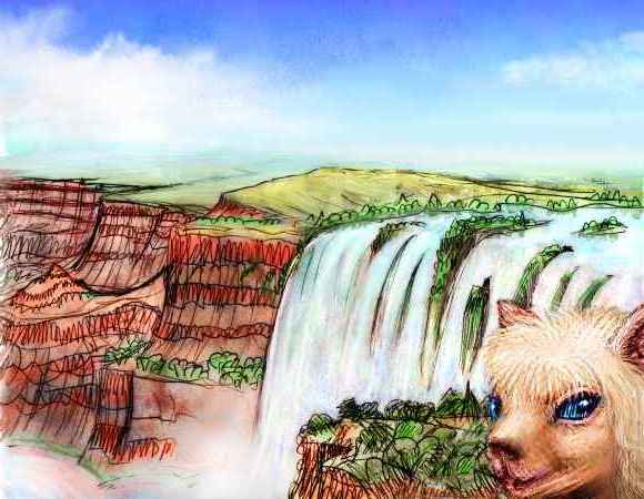
The Talaya rises from snowy dorsae (long, straight compression ridges) in central-western Thoris Upland, winds briefly through alpine meadows, drops to a "terrace" hundreds of km wide, dotted with "scrub oak" and "pine", where it collects the runoff from much of western Thoris, then pours 200 meters (660') in a broad fall like Iguazu or Niagara. Talaya Canyon then winds across the Liklik Desert; as with Henikaa, flyotes and lobbras farm Talaya's floor.
Just south of Talaya, strange straight ridges angle across our path. Boulders and rubble, not solid rock, they look like the Road Crew Of The Gods went on strike halfway through a job, emptied their dump trucks, and never came back. At first the ridges seem parallel, but not quite; they converge on a low range of hills off to the side. Curious, you detour to climb them near sunset, hoping for a view ahead. They're only 300 meters high (1000'). But they're not hills. The ground drops away into a round gulf of blue shadow--Obbelak Crater, a flawlessly preserved impact basin 60 km wide (35 mi). From here you can see the rays of lighter rock run out past the horizon.
Past Shinnif, the red desert slowly pales to orange and gold, and grass becomes more than a sometime thing. This time you recognize that funny-shaped range of hills to the southwest as another impact crater. To be seen at this distance, it must be much bigger, and it is. Thas Crater is fully 150 km rim to rim (over 90 mi). There's another difference: we've truly left the dry zone. The crater floor is a broad, shallow lake 1.5 km below the plains. Unusually large, intelligent flyotes farm the shores along with lobbras.

The plains around Thas are golden grass dotted with thorn-trees. Herds of lobbras, wingbok and veltaurs abound. You could almost mistake it for Africa... until you take off your oxygen mask and nearly collapse.

Ahead, as you trek southwest, the trees clump into groves--the outliers of Polodona Wood around the shores of the small Chepsillo Sea.
SOUTH
Chepsillo "Sea" is a misnomer, but everyone in the region calls it that; it's really just a big freshwater lake 450 km long and 220 wide (280 by 140 mi). Its source is high in the huge, volcanic Chinchak Range to the south. The Chepsillo River flows north through Polodona Rainforest to Chepsillo Sea, then winds north 900 km (560 mi) through steadily drier savanna and near-desert to the Sea of P'tang.
West of the river and lake is Lushanta Veldt, a warm, rolling plain 1000 km (600 mi) wide, dotted with trees that thicken to groves and open woods in the south--the fringes of Polodona Rainforest. It's not spectacular, but pleasant country unless the rains fail. Veltaurs, lobbras and thotters predominate, plus (of course) thotters on the streams.
Across Lushanta to the west (on the horizon in the orbital photo) is the lake country of Dupdup Trench. Dupdup is flyote land; at least they're the only flying people who've settled this air oasis. Veltaurs, lobbras and thotters live here too, but being flightless, they enjoy only the dense air's secondary benefits: a stable, hot climate, no sunburns, invigorating air, fertile farmland... Lebbirds and wingbok could certainly fly here too, but they haven't yet reached Dupdup Trench. They may be a long time coming--it's 2000 km over jagged mountains to the next oasis where people can fly.
The north end of Dupdup Trench trails off into the Artolian Chaos west of the Sea of P'tang; we've come full circle.
World Dream Bank homepage - Art gallery - New stuff - Introductory sampler, best dreams, best art - On dreamwork - Books
Indexes: Subject - Author - Date - Names - Places - Art media/styles
Titles: A - B - C - D - E - F - G - H - IJ - KL - M - NO - PQ - R - Sa-Sk - Sl-Sz - T - UV - WXYZ
Email: wdreamb@yahoo.com - Catalog of art, books, CDs - Behind the Curtain: FAQs, bio, site map - Kindred sites