South Seas
by Chris Wayan, 2005-6
Map, Tharn's homepage, Peoples of Tharn, Regional tours, Geology and Evolution, gazetteer, terms explained. More worlds? Planetocopia!
INTRODUCTION
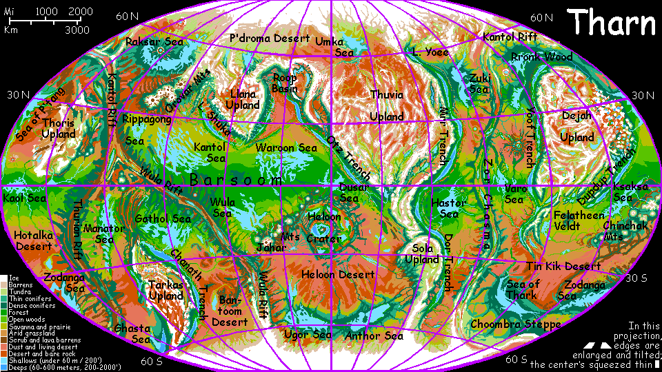
The South Seas, properly called the Thark-Zodanga Basin, is a huge region, but sparsely populated except near the seas and rivers. The north is mostly desert: the Tin Kik in the west and the Hotalka Desert in the east. The only large oasis is the Ngippo River, fed by snows from the Chinchak Range.
The south is something else: a wide belt of cool-temperate forest stretches from the Sea of Thark to the Zodanga Sea, some 5600 km (3500 mi)--a fourth of the way around the world!
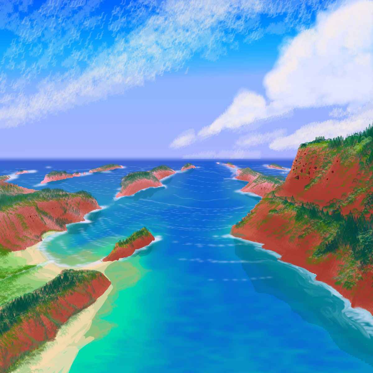
Thark is shallow, but big--1500 km long and up to 320 wide (950 by 200 mi). The shores look quite Nordic: cool, dark evergreen forests. In wetter eras a river links Thark and Zodanga Sea to the east; they've occasionally even merged, forming the nearest thing to an ocean this world's ever seen, or is likely to. Even now, in a moderately dry era, they form a single cool-temperate belt. The sea's brackish but drinkable; most of Thark's water comes from snowmelt off the tundras to the south. The south shore collects silt from these streams and tends to be shallow, muddy and marshy.
Four species live here, in different habitats, roughly north to south:
 Along the shores and on the islands (notably huge Dzuralthe Island off the north shore) are thotter villages. These amiable, hyperactive people fish the sea, mostly by stampeding fish into float-nets and hauling them back on rafts. In marshes they raise small semi-aquatic dinosaurs called parru. The copious rubbery eggs of the parru are a staple of thotter diet, and are a valued export item, rivaled only by smoked fish and lotus seeds. Thotters, unlike Terran otters, are quite omnivorous; they also farm reeds with sweet, starchy cores, marsh grasses with oil-rich seeds, lilypads and floating flowers for salad and fruit.
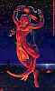
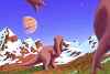
 The evergreen forests are home to mops: squawking, feathered, fierce kangaroos, or, if you prefer, gentle velociraptors (I know that's like "honest lawyers"). Their lifestyle vaguely resembles Northwest Coast Indians, living in settled villages of intricately carved wood, including "totem" poles (which aren't clan- or family-totems at all, but images of spirit-allies met in dreams). Food sources: an annual salmonlike fish-run, berries (mops fell trees not just for lumber but to create berry-bush clearings), the growing tips of Tharnian evergreens (pleasantly spicy, but don't overindulge if you're not a mop; like Terran evergreens, they're rich in sugars and vitamins, but also resins (antifreeze?) which only mops are adapted to digest in quantity); and the nuts of half a dozen tree-species bred to be high-yield, that mops fertilize with fish-waste--which, along with wood chips, also feeds mushroom-gardens.
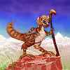 South of the forests is cool, windy Enk Steppe. Here live camaroos, who Terrans would see as a weird hybrid--a grazing animal that herds grazing animals. While camaroos aren't strict herbivores, they do browse extensively while guarding flocks of smaller sheeplike creatures, which they milk. In the northern hemisphere these are little furballs whose name translates as "woolly anoxia", for their long, fine, prized coats and their ability to graze slopes so high that even camaroos grow faint. Here in the south, the herds are of a larger tundra-species looking rather like reindeer. Yes, reindeer, not dinosaurs, chickens or mosquitos. Hairy quadrupeds! Not all Tharnians are centauroids or bipeds. Life here crawled out of the many seas many different times. I just haven't happened to mention many quadrupeds because few have become intelligent (thotters are one exception). There's a reason for that: hands! Quadrupeds that evolve intelligence tend to become bipeds. Only centauroids can afford to keep four feet on the ground... In a way, these camaroo-reindeer flocks are another solution: one species walks upright to free up hands, guarding the herd more effectively than, say, large heavy horns, while the other specializes in turning grass to milk, feeding both.
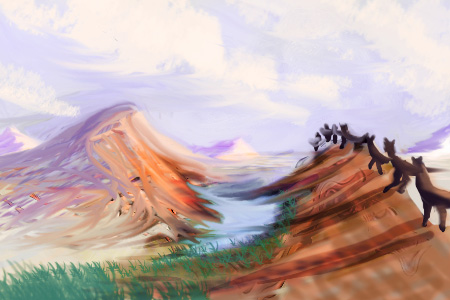
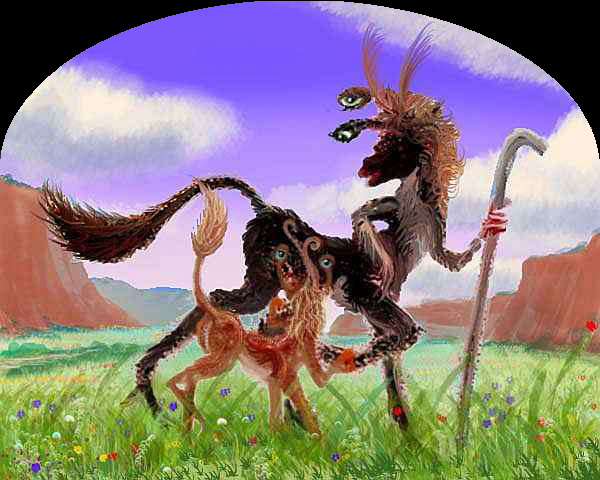
 Further south, the land slowly rises, turning rocky. Grasses grow sparse; lurid lichens splash the rocks. The white line on the horizon is the low but massive range of Zor Chasma. This rift zone borders the polar ice cap, and indeed contains it--the rift itself normally stays ice-free, with saltmarshes and hotspring-fed lakes along its floor, punctuated by small volcanoes. North of the rift, shallow braided streams drain low, windy ridges and tundra plains. Only mamooks can survive here--elephantine nomads able to digest cellulose and lichen (proverbially, mud and ice--the camaroo term "mamook" means "ice-eater"). The sparse vegetation keeps them traveling to avoid overgrazing. Mamooks travel light, so their material culture is limited; but their inner life is complex--they're famed as psychologically astute storytellers and performers.
NORTHWEST: TIN KIK DESERT
North of the sea, the mop-forests fray into savanna bordering the Tin Kik Desert. It's a flat, dry, brownish plain most of the year--unappealing country, and not only to the Terran eye. Water's unreliable, except for the Ti Tip Sea---a shallow, brackish lake draining much of the western Tin Kik Desert and southern Felatheen Veldt. Marshy, muddy and slightly alkaline, prone to both flood and drought, it's mainly a watering hole for nomadic centah herders in orbital summer, when other sources in the desert dry up. The only year-round residents are fifty billion flies.
And Ti Tip's about the best the western Tin Kik has to offer.
Wait--there's one narrow exception. The P'tarth Mountains cross the equator, forming a migration corridor for cold-adapted Tharnian species traveling north-south. Each orbital winter, caravans trek south along the West P'tarth Range. Most of its streams flow either west into Lake Murra or east into Lake P'Tarth, but at its southern tip, where it trails off into the desert plain, is one river that doesn't--the Mintibom flows due south over the desert to the Sea of Thark. Some years it sinks into its bed halfway south, becoming a mere chain of pools or a gravel groove... but digging always reveals drinkable water.
Earth's trade was shaped by straits and isthmuses; great ports are often world-wise and progressive, while continental interiors languish in absolutism. Dry Tharn's equivalent bottlenecks are caravan-routes with reliable water, favorable temperatures, or dense air. Due entirely to the annual Mintibom caravans, rugged, lonely-looking P'tarth is distinctly more cosmopolitan than the surrounding plains and deserts!
EAST: ZODANGA BASIN
East of Thark Sea, the woods go on for days; low wooded mesas (former islands) above dense-forested riverbottoms. Away from the sea, days grow hotter, nights colder, but the forest barely thins; storms here blow east off the sea. 600 km inland, the rivers are still so slow and meandering you can't tell they're winding east not west now: an imperceptible divide.
1200 km from the Thark shore, nights grow mild again, and the next morning, silver gleams to the east: the shores of Ting Kom Bay, on Zodanga Sea.
Zodanga is the largest sea in the southern hemisphere--nearly 3000 km long, though only 500 wide (1900 by 300 mi). The shoreline is very shallow--and that has consequences. In wetter eras, Zodanga grows, often doubling in size; now and then it even merges with Thark Sea to the west, forming a genuine ocean--and greening much of the southern hemisphere.
Even today, in a moderately dry era, it nourishes huge Zodanga Wood on its west and south shores--an evergreen forest bigger than Alaska. The great wood you just crossed is only its west end.
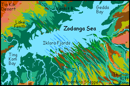
The south shore of Zodanga Sea looks peculiar even from orbit--a series of narrow, straight fjords and capes 80-160 km long (50-100 mi) but just a few miles wide. The walls, from 1-600 m high (300-2000'), range from steep wooded slopes to sheer black cliffs. The set of parallel cracks and ridges creating them run inland all the way to the Thurian Rift Zone.
"Fjords" is a misnomer, of course--the Iklora Fjords weren't gouged out by ice at all. They mark the faults of a fracture zone, the most visible of dozens on Tharn. Fresh crust spreads from Thurian Rift, but when the rift curves, as it does around the Zodanga Basin, it squeezes and splits into mini-plates divided by fracture zones like Iklora--fossae (long straight cracks), cliffs, and ridges. These fractures actually cross the shallow sea bed and reappear, though less impressively, on the north shore.
A hundred thotter villages nestle in these fjords; their still, sheltered waters, fertilized by the silty rivers descending from Thurian Rift, are ideal for thotter aquaculture.
Up the rivers, flyotes have dug out great cliff-villages with spectacular views, gliding down daily to farm the rich bottomlands. This washboard country, nearly impassible on foot, is a flier's paradise. The thin air does put a size-limit on this subspecies of flyote; their language and culture are simple compared to the big-brained supercharged sophisticates of, say, Dupdup Trench. But they make up for it in enthusiasm. Perhaps it rubs off from the thotters they trade with, or maybe it's just the land. Iklora's lovely country, and if chimps can appreciate beauty (they've been seen climbing hills hand in hand to watch sunsets), why not Iklora flyotes?
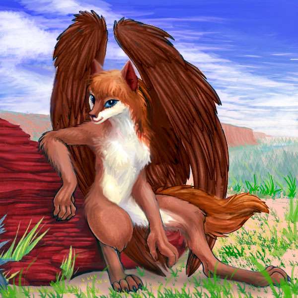
Indeed, it may be that out of Iklora will eventually come a truly intelligent flyote who can still fly at bedlevel. All the ingredients are there: stable, generous food supply, large population, ideal habitat--except for air pressure. If it happens, such flyotes will revolutionize Tharnian civilization--even, perhaps, dominate it.
In contrast to the Zodanga Wood or the fertile valleys of Iklora, the northeast tip of Zodanga Sea sticks into the dry zone around 20-30 south; beyond the marshy shores, the Hotalka Desert stretches a thousand km.
Hotalka has some oases: shallow, rushing, stony rivers like the Podraap and Gerpook descend from Thurian Rift, whose ridges rise 3 km (2 mi) above the plains here, winding through the desert like a railroad bed raised by giants with no compass. And down in Thurian's central rift valley, hotsprings and mud volcanoes simmer. Such desert pools are bacterial paradise, but hell for anyone else; the rift itself is nearly uninhabited.
There are a few miners. And in the alpine meadows atop the ridges flanking Thurian Rift, camaroos herd flocks--though only in summer. Permanent residents? A few mop villages nestle in the greener canyons of the fracture zones. The cliffs here look like ideal flyote habitat too, but they have an invisible flaw: the region's too high, and in the thin air, flight's just too difficult for flyotes large and clever enough to plan cliff-palaces of stone. Go high enough to squeeze out rain, and the air's too thin; descend to flightworthy levels and the desert opens out.
Thurnian Rift's a zone caught between.
The plains north of the Zodanga Sea have even fewer oases to relieve them. At first it's an open pinewood, but it quickly thins to prairie, then near-desert. The huge Chinchak Range cuts off rains from Polodona Basin, creating the Tin Kik Desert in its shadow. Tin Kik does get weak winter rains off Zodanga Sea, but they're unreliable. It's like Earth's Sahel--livable most years, but a string of bad years can wipe out everyone.
A few bands of lobbras and veltaurs browse here during rainy years, and centahs herd flocks of losha, but the deep desert is nearly uninhabited. Agriculture just isn't reliable in the Tin Kik. With one spectacular exception:
THE NGIPPO CULTURE
The Ngippo River, 3200 km long (2000 mi), is the longest on Tharn. The Ngippo collects most of the runoff from the south side of the huge Chinchak Range. It forms a riverine oasis crossing Tin Kik Desert, providing reliable irrigation water in its long valley, much like the Nile. It's not an idle comparison: megalithic ruins worthy of Egypt still loom over these fields.
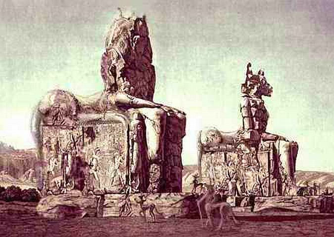
Ancient Ngippo was one of Tharn's only hierarchical civilizations, ruled by a caste of water-priests who allocated irrigation and judged field-boundary disputes. They slowly became a true elite, commanding labor that built great stone tombs for their leaders.
At first these were flat-topped cones up to 120 m high, apparently effigies of the great shield volcanoes that seemed to be the source of all the world's water; later, one finds huge stone images of the deceased, typically crouched on a dais--to human eyes they look half pharaoh, half sphinx.
It's revealing that the ancient Ngippans, being so isolated, were essentially unispecific--Ngippo's a lobbra name, and that peculiar people, a sort of cross between lobsters and zebras, farmed the valley almost alone for eons, until the camaroo trade-network spread to the southern hemisphere 6000 years ago.
One species, and a classic Terran hierarchy! Coincidence? Doubtful. Civilizations composed of a single intelligent species are all we know, but that's a rare situation on Tharn; and when trade grew, the hierarchy soon destabilized. It's hard for peasants to go on worshiping lobbra pharaohs who claim to command the Great River, when you know of prosperous non-lobbras with egalitarian customs--even different biological needs.
Is our own tendency toward hierarchy really inherent in our character, or just an unfortunate artifact of our isolation?
I'm seriously proposing this, I think: in another world-model with a desert river inhabited by just two intelligent species, I was forced to postulate a quite feudal civilization; but it seemed unstable. As soon as a third species upset the balance, the Ytrebil Culture overturned its hierarchy too. Like governments with several independent branches, civilizations with three or more intelligent species will, I predict, tend toward egalitarianism; it's cultures with just one or two intelligent species that may develop rulers and ruled.
In Ngippo, some temples and tombs still stand, though battered; and not all the battering's due to time. Some were defaced or toppled in rebellions lasting two or three generations before the last of the lobster-pharaohs fell. And the lobbras have no regrets.
A TALE OF CHOOMBRA STEPPE
The forests bordering Zodanga Sea fade to the south, as the land rises toward Thurian Rift. This windy, rolling land, called Choombra Steppe, is drier and much colder: there are even small regions of tundra. Only a few mamook bands wander here--but one of their wanderings had epic consequences. Precisely because their prime habitat is so broken up, these mamooks have turned to trade as insurance against famine in bad years. They mine the Rift's pools and volcanoes: copper, sulfur, obsidian, manganese, iron. So much trade with camaroos and mops gave them a detailed if second-hand view of the deadly hot lands to the north. And one travelers' tale made their trunk-hands flare and sniff whenever they heard it--the tale of an equatorial range so high and cold no one could settle its peaks.
After years of planning and debate, a band of mamooks draped in camaroo-bought white robes set out in orbital winter for the Chinchak Range, 2500 km north (1600 mi). Trekking in the cool of the night through Zodanga Wood, napping neck-deep in creeks and ponds during the day, swimming the Ting Kom Strait, they headed northeast past Lake Fentho to the shallow, stony Yenkit River.
This snowmelt stream's a little sister to the Ngippo--unreliable and thinly settled, but flowing directly from their goal. In winter, the water was low, but there was enough to keep their robes wet, cooling by evaporation. For three days (nearly a Terran week) they staggered up this stony, searing valley (a good 20-25 degrees C--room temperature!) past winding black snakes of lava and red valleys of dust. At last they climbed into hills where the heat became bearable, and they could wait out the day in the shade of spindly trees. And the rumors were true! Ahead on the horizon was... well, there was no horizon. Just endless slopes rising into the haze--cool forests, alpine meadows, and icy peaks rising into the stratosphere.
The Chinchaks are a line of shield volcanoes like Hawaii, but in Tharn's low gravity they rise to nearly Martian heights--Mt Tsol reaches 16.4 km (54,000'), the highest in the world. It's a place only a mamook could love--or even live.
The band sent word back through trade-caravans of camaroos and mops, and a few more immigrants trickled in. Their descendents settled over 2M sq km (nearly a million square miles) of upland, and like their ancestors, entered close relationships with the other species just below them on the mountainslopes.
Today they're perhaps the richest, most progressive mamooks in the world.
They do have one quirk. Every midwinter noon, all the Chinchak mamooks turn as one to face the summit of Mt Goom, and foghorn. What are they saluting? Forty thousand feet up, under a starry noon sky, lies a great black stone pinning down a frozen heap of old white robes.
That's what comes of talking to strangers.
World Dream Bank homepage - Art gallery - New stuff - Introductory sampler, best dreams, best art - On dreamwork - Books
Indexes: Subject - Author - Date - Names - Places - Art media/styles
Titles: A - B - C - D - E - F - G - H - IJ - KL - M - NO - PQ - R - Sa-Sk - Sl-Sz - T - UV - WXYZ
Email: wdreamb@yahoo.com - Catalog of art, books, CDs - Behind the Curtain: FAQs, bio, site map - Kindred sites