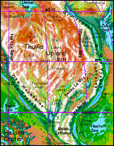
Thuvia Upland
by Chris Wayan, 2005-6
Map, Tharn's homepage, Peoples of Tharn, Regional tours, Geology and Evolution, gazetteer, terms explained. More worlds? Planetocopia!
INTRODUCTION
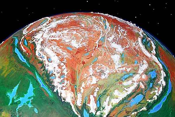
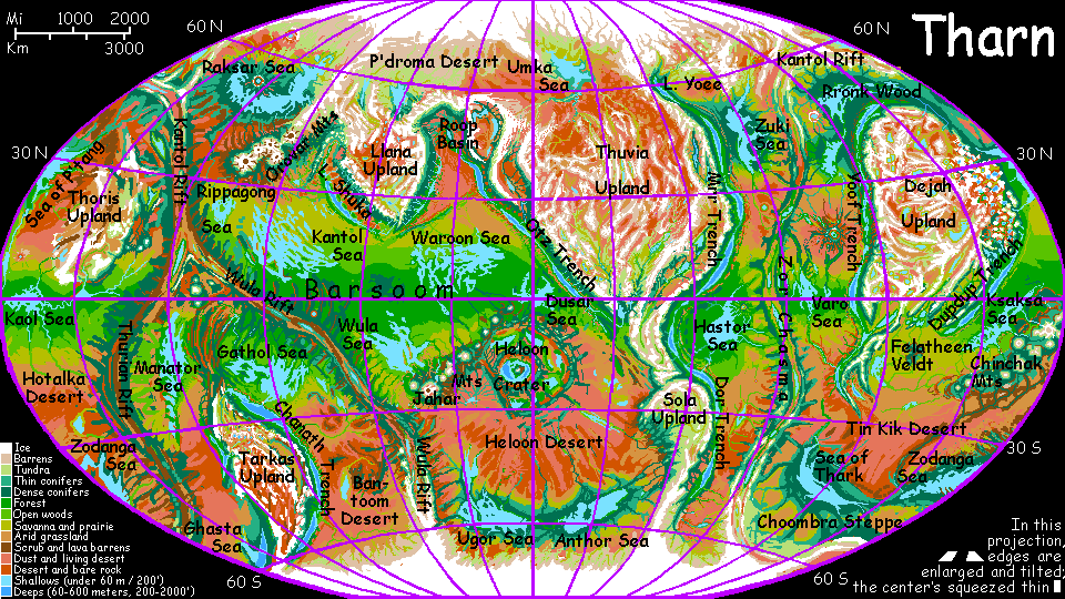
Thuvia is the largest upland on Tharn, around 12 million sq km (5M sq mi), nearly twice the size of Australia. Though it looks quite Martian, all of it is inhabited, though sparsely (especially the higher, colder north). One intelligent species, mamooks, may even have evolved here; they certainly spread from Thuvia to the southern hemisphere via Molak Isthmus. And the deep trenches flanking Thuvia, Mrr on the east and Otz on the west, are some of the richest biomes on Tharn.
If this were Earth, Thuvia would be a rugged mid-sized continent--North America, perhaps--with inland ranges 2-3 km high, taller coastal ranges, and island arcs off its east and west coasts. Indeed, southern Thuvia breaks up into deep basins that on Earth would be much like the Caribbean or Gulf of Mexico. But on Tharn, these basins are exposed--deserts and steppes ringed by mountains.
Though Thuvia, dropped on Earth, could pass for a continent, there are differences. The biggest would be hidden by the sea: both "coasts" are subduction trenches. This is an unearthly response to squeezing! Terran continents usually move along with one plate and slip over another, but Thuvia floats above both--it's a third plate forcing both "sea-floor" plates under at its rim. Only a few small Pacific plates do this, but most of Tharn's big uplands do. Why are floating uplands common on Tharn? Is it the lower gravity, the lack of oceans, or the faster crustal movement, stimulated by tidal massaging from huge Zeus and nearby Pegasia?
My bet's on sheer tectonic vigor. Even from low orbit, you can tell the pressure on Thuvia's extraordinary: there are no plains of any size, no analogy to the American prairies. Between the rim-ranges, Thuvia's as corrugated as Tibet. These long straight ranges, called dorsae, are almost certainly compression features.
A final difference can be seen only on the altitude map. Thuvia's north edge just trails off; instead of a "continental shelf", the land just sags from Tibetan ranges down to rugged desert and eventually a tundra plain around the Umka Sea. There's a reason for this: Earth's seas create the continental shelves. Sediment washes down from mountains onto plains and tends to collect there around sea level. To grossly oversimplify, our shelves are just old Ice Age shorelines. With no sea, only the rims of Tharnian uplands that have subduction trenches are sharply defined. Most rims do in fact have trenches, but northern Thuvia and eastern Sola Upland are examples of gradual slopes dropping many kilometers over 1-2000 km. Rare on Earth! (Some of the seafloor off New Zealand and Greenland might qualify.)
MOLAK ISTHMUS
Molak is a narrow highland linking Thuvia and Sola Uplands. Really more the triangular tail-end of Thuvia than a simple mountain chain, Molak narrows steadily to the south until Trunzip Pass. Think of it as Central America... if all our seas dried up.
The Molak highlands truly function as an isthmus, not just a mountain wall: they're a migration corridor for high-altitude species like mamooks that can't tolerate heat. Yet they are a barrier for lowland species that fly like lebbirds and trench wingbok, or require Earthlike oxygen concentrations like lobbras and elaffes.
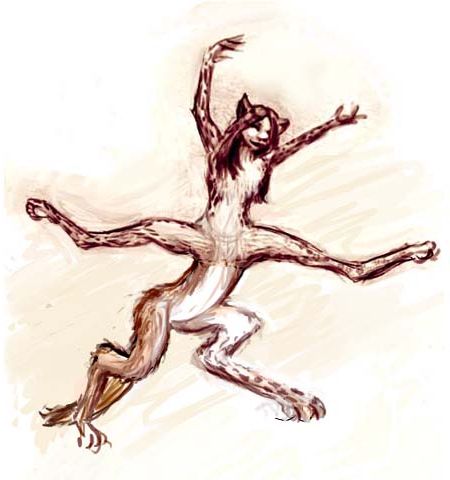
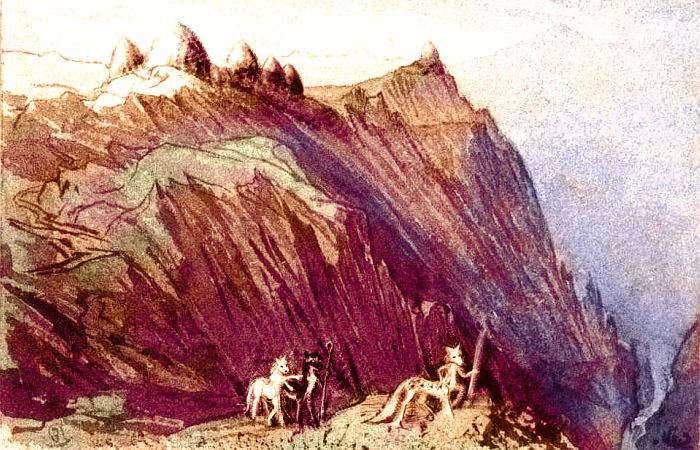
Trunzip Pass, the east-west valley at the very bottom of the orbital photo, is Tharn's Panama Canal. Of course it handles not ships but patient, slow alpine caravans staffed by camaroos, a bipedal people who look like daddy was a velociraptor and mama was a kangaroo. A polar kangaroo. With a lot of llama brains, stamina and stubbornness thrown in.
It takes all that stubbornness to cross Trunzip: it's a weeks-long trek from Yarr Trench in the east, climbing six kilometers (20,000'), and down four more (13,000') to Barsoom Basin or six km into Otz Trench in the west. Like climbing the Himalaya on foot from the Ganges Plain--and right back down.
Like poor Sisyphus... except camaroos like exercise. And get paid plenty--everyone knows how valuable their services are. Well, "paid" in a very broad sense; Tharn as a whole lacks a formal currency system, though camaroo do use shipping tokens that function like money. But any run can earn you those; that's not the pay that makes Trunzip Pass special.
Trunzip camaroos get...
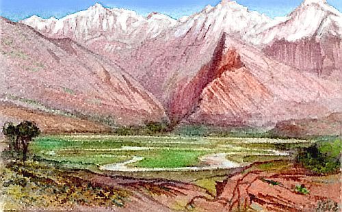
The lake-dotted alpine basins between these ranges, 3-4 km high (2-2.5 mi), are close enough to the equator to be quite mild for Tharnian uplands. Few trees, but not as dry as our Altiplano either; during orbital summer, rich grassy meadows, more like some of the higher steppes of Central Asia, or parts of the Alps. Camaroo villages are relatively dense here; grazing is rich and agriculture is at least possible.
SOUTHERN THUVIA
Southern Thuvia's basins and ranges are a heartland for camaroos and mops. Though 4 km above datum (13,000' up), these are low-latitude, fertile altiplanos. If anything, the altitude helps. For example: two leaf-shaped basins run northeast-southwest, side by side; yet due to altitude they couldn't be more different: Zozar and Foori Basins.
Zozar Basin
The Zozar Lakes (upper left in the orbital photo) are a marshy chain on a cool windy prairie nearly three miles high. Along with Molak, it's the camaroo farmbelt; they grow specialized seed-, root- and leaf-crops along rivers and by lakes. Camaroo root crops are hardier than traditional Inca potatoes, but even Zozar's bottomlands are harsher than the Andes; away from streams, farm-yields are poor. Herding pays better.
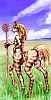
So even here, most camaroo graze zhoopas (small grass-eaters like shaggy psychedelic emus) for their colorful, insulating feathers (for decoration, padded thermal clothing, furniture-stuffing and export), and more importantly, their milk and their rubbery eggs. Camaroos, while primarily herbivorous and able to digest modest amounts of young grass, can use the fat and protein harvested from grazing animals more easily. They generally don't eat zhoopas, treating them rather like pets, but zhoopa eggs and milk let them use the higher, stonier altiplanos far more efficiently.

Along the lower Zozar River, mops herd their own flocks. Being omnivorous, they don't treat zhoopas as pets, and eat them (sparingly; it's like eating money). Mops also harvest and work the timber found along the lower river (and nowhere else in Zozar). Even far upriver in the heart of camaroo country, carpenters, sculptors and builders are often mops.
The lower basin, being near the equator, is cool but hardly cold by Tharnian standards. Veltaurs could almost settle here, grazing and farming the warmer plains. But in orbital winter they'd have to wear coats (or at least a sort of horse-blanket) and no veltaur would do such a dreadful, repressive thing! Hide one's body? Limit self-expression? Unthinkable. The freedom to fidget has a price.
Instead, the basin and its arc-range are the home to centahs, another wingless centauroid with a better attitude toward saddle-blankets. Not that they really need them most winters; these tribes are a unique subspecies: large, with angular faces, and long thick fur.
Cupped in dense forest, Lake Tebbik (smaller lake on lower left) moderates the climate of the lower Zozar Valley. Though still 3.5 km up (11,500'), it's sheltered and not far from the equator. A deep slash of a canyon cuts drains Lake Tebbik southwest to the tiny Bundaroo Sea.
Names aside, the two bodies are nearly twins: brackish Bundaroo isn't much bigger or saltier than Tebbik. It's much warmer, though; at only 2.5 km (8000'), orbital winters get cold, but snow is rare, and the shores are densely wooded. Many subtropical rainforest species reach up into this sheltered valley.
And following their food sources came bos--the highest-altitude population of these rainforest dwellers on Tharn (they're more common in the lowlands woods and savanna to the west). This lush valley, sheltered by spectacular peaks, isn't just a fascinating ecological island, but a cultural one: about the only place where these tropical types mix with cold-adapted camaroos and mops from upriver, who can handle the warmth because of the dense shady woods.
Foori Basin
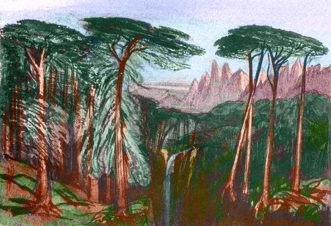
Zozar Valley ends to the southeast in a long straight wall: the snowy Dokko La range. Beyond lies the Foori Basin, much lower than Zozar: just 1-2 km above datum (sealess Tharn's "sea level"). Foori's warmer, but drier too; large stretches are semi-arid prairie. Only irrigated veltaur farms flourish here, in the riverbottoms and near the Foori Sea. On the steppes and in the canyons of the surrounding Dokko La and Yarr ranges, centahs herd a sort of domesticated roo.
Wood is scarce in this dry basin--even the hills are treeless except along watercourses, for the storms arising in damper, dense-aired Mrr Trench all spend themselves on the eastern, outer face of the Yarr Range. Arc basins rarely get much rain. So the thatched beehive huts in the background are typical: arches of cob (adobe and straw) over a tough fishnet for quakeproofing. Weaker than concrete with rebar, but the same principle, and a lot easier to mend if it cracks! And aside from a reusable willow frame for building the arch, such domes need no wood at all.
They're surpringly pleasant inside; light reflects off those arched ceilings and they feel bigger than they are. No dark corners...
The upper end of Foori Basin, around Lake Kitlei, is greener, more like Zazor--lush prairies where thousands of plains wingbok graze and scattered trees attest to the higher rainfall. But this region's well above datum--air pressure is less than atop Mt Everest, so thin the average plains wingbok would have trouble flying here. The local subspecies has large wings but a dwarfed body and head; the brain is so small these "plateau" wingbok rarely speak more than single words. Half-people!
And along these upper rivers feeding Lake Kitlei, the veltaur farms disappear entirely. Veltaurs like it hot; even these tropical highlands, just 2 km up (6600'), are too cool for them. They're replaced by centah, camaroo and mop villages.
EASTERN THUVIA
North of Lake Kitlei is a mountainous knot where the Mrr Range, the Dokko La and the Worawora Mountains come together. Glaciers and high barrens, uninhabited and uninhabitable.
North of this lies a second arc-basin, Worawora Valley. But despite its appearance on the map (not so different from Foori Basin), here the floor is so low, in places even below bedlevel, that both biologically and geologically it isn't really part of Thuvia Upland at all. Worawora is therefore covered in the tour of neighboring Mrr Trench--though it fits poorly there too.
WESTERN THUVIA
The Zozar River isn't the only one feeding the Bundaroo Sea. The Trelomm River, 2400 km (1500 mi), drains most of southwest Thuvia. Braided and milky with glacial silt, the Trelomm runs south from three alpine lakes: the Agh in the north, the central Ghoot, and the Trelomm in the east, each 200-250 km long and perhaps 100 wide (125-160 mi by 60 mi). Only Lake Trelomm is below 5 km high (16,000'). Not coincidentally, Trelomm's the only one with extensive meadows and marshes. The Agh branch to the northwest is far longer, but the Agh Basin is so high dry and cold it's nearly sterile--in the rainshadow of the Hai Lek Range and Otz Mountains to the west.
Even once all three branches merge, the Trelomm Valley remains subalpine, with only a few low trees near the river. Real forest covers only the last few hundred km to Bundaroo.
This lower stretch is mostly mop country; camaroo villages cluster around Lake Trelomm, but otherwise the region supports only nomadic mamooks and a few camaroo herders--the original camaroo lifestyle, before they learned agriculture or started leading caravans all over Tharn. Trelomm is just a thinly populated ghost of the Zozar Basin to the east. It's just a bit higher and a bit drier; but this close to the edge of what life can take, that slight difference has harsh consequences.
CENTRAL THUVIA
Central Thuvia is Tibetan--even more so than Tharn as a whole, I mean. Cold desert valleys below long snowy parallel ranges--mostly compression ridges, crossed or broken in places by fracture zones where unequal pressure inward has raised lower ridgefields at right angles to the main ranges. The result? A labyrinth with no way out. At a lower altitude, water would dissect and drain these basins, but the region's so high, cold and dry that erosion's slow. As a result...
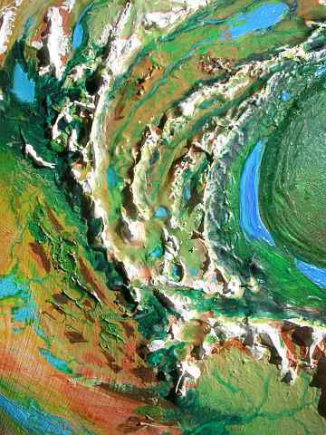
Most basins have no outlet, so lakes here are brackish, like the North and South Dzel Seas in the upper center of the photo, each around 320 km long (200 mi). These briny fingerlakes lie end to end in a marshy valley 4.5 km above datum (14,800'), between north-south compression ridges rising to 7.5 km (24,600'). Over the mountains, dozens of lesser fingerlakes streak the rusty plateau. Lichens crust the rocks above, painting crags with lurid golds and oranges, but the only true greenery here is along the marshy streams on valley floors, which are frozen three-fourths of the year. Hard, lonely country.
Did I say Tibetan? Under the noon stars and violet sky, Martians will feel right at home.
The only residents here are a few camaroo herders on the bottomlands of Dzel, and small bands of wandering, lichen-eating mamooks. Though even a few of those huge people seem like a lot. And on such marginal land, they are. Keep moving, or strip the country bare and starve...

NORTHERN THUVIA
By 45 degrees north, the great plateau starts to sag; streams begin running north, merging into tributaries of the Yamfit River, probably the longest on Tharn. The West Yamfit rises in the arcuate Roop Range; the East Yamfit, in the long parallel ridges of central Thuvia. Both branches of the upper Yamfit are alpine; only the lower stretches near their confluence have boreal forest.
But not right down to the river's edge. Most years, the spring thaw on the lower Yamfit is a noisy affair. The ice groans and breaks into slabs that race like bumper cars downstream, chewing up the shore. However, flooding isn't massive, though the headwaters are far to the south and you'd expect them to thaw first, backing up behind the ice dam lower down. This happens annually on many Siberian rivers, but the upper Yamfit, though far to the south, is also 3-4 km higher up; most years, the arctic lower stretch thaws first! Most years.
But when a heat wave hits the south first, the lower Yamfit thaw is one of the noisiest, violentest events on the planet; the ice river bursts. Groaning splinters of ice the size of ships ride black water into the surrounding woods, to collide and heap and grind trees to pulp for miles around.
The Yamfit ends in a huge, silty, reedy delta at the east end of the Umka Sea, a cold marshy sea 700 km (450 mi) long. Other rivers feed the Umka; the wooded Yoee flows down from the eastern rim of Thuvia to join the Yamfit Delta, and the shallow, braided, treeless Umka feeds a strip of relatively green tundra in the arctic near-desert north of the Sea.
The Umka basin sounds like a lonely place--but every summer, the north shore of Umka comes alive. Mamooks gather for a chong-ma--a music festival, a competition, and a marriage market all in one, where mamooks of both sexes try to impress potential mates with ballads and drum-stories. The plain thunders for miles...
The pink areas northwest of the Sea are a Tharnian oddity. The prevailing winds are off the polar cap, but when a dry "storm" rolls in off the P'droma Desert, fine red dust drops on the ice. This can create a salmon-colored stain. But the unnatural pink you see is a further step: bacterial staining. Anyone in sunny snow country where pits develop in melting snowbanks has seen patches and streaks of such bacteria, often called "watermelon snow." But on Tharn these colonies, nourished by the dust, can run for miles.
I've often wondered if some of the vivid colors in the "topo terrains" near the poles of Mars are bacterial. True, bacteria there would face radiation and cold worse than Tharn's.
World Dream Bank homepage - Art gallery - New stuff - Introductory sampler, best dreams, best art - On dreamwork - Books
Indexes: Subject - Author - Date - Names - Places - Art media/styles
Titles: A - B - C - D - E - F - G - H - IJ - KL - M - NO - PQ - R - Sa-Sk - Sl-Sz - T - UV - WXYZ
Email: wdreamb@yahoo.com - Catalog of art, books, CDs - Behind the Curtain: FAQs, bio, site map - Kindred sites