 INTRODUCTION
Venus Unveiled: Lada
INTRODUCTION
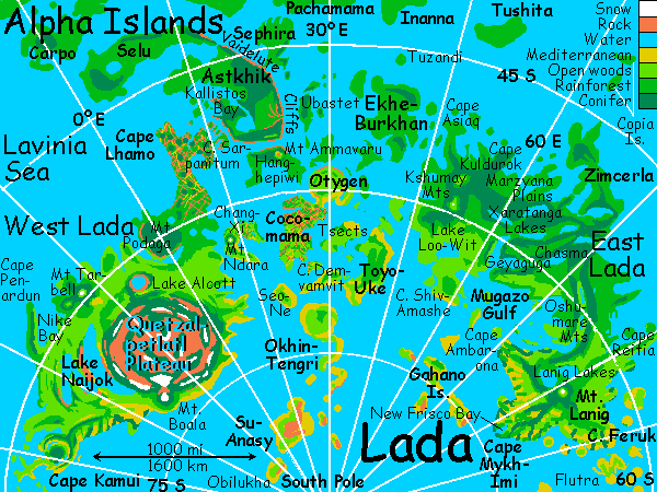
Lada, near the south pole of Venus, isn't a continent exactly, nor an archipelago--something between. Like Indonesia times ten--or Ursula Le Guin's "Earthsea" made real.
 LADA: THE MISTY EAST
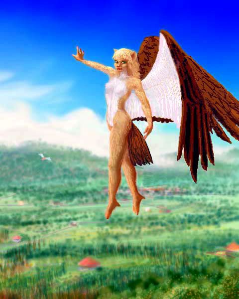
Let's tour the place. Strap on your angel wings! Ridiculously small, aren't they? They'd be useless on Terra. But the air pressure on Venus is more than triple Earth's, so flying's as routine here as driving is on Terra. In fact, many of the locals you'll meet will have real wings, living ones, genetically engineered. So grab air and let's go.
You're gliding over a shallow sea, on a mild sunny day. You've been touring the scattered Flutra Islands, heading always west--from mediterranean Katl-Imi, where the Trans-Aino blimp landed you, to Deobako and the Ruad Isles, then to green Flutra, larger than Sicily. As you cross the hills of Flutra, the dark-forested cone of Pahto rises off to the north. You're over the beach now, and out into the Feruk Channel--below you, sandy shallows of gold, green and turquoise alternate with dark kelp forests full of iridescent glints of green, purple and bronze.
A long coast slowly rises ahead--Cape Feruk. Mainland Lada at last! You ride the updrafts over tawny coastal hills, heading southwest. Redwood groves fill the coastal valleys. You sleep under their shade. It's the only shade you'll find--for night never falls. This is Venus! Daylight's seven Terran days long--today was Sunday, when the sun rose. When you wake it'll be Monday. Then Tuesday etc., through Setterday (when the sun sets). Then Dusk, Eve, Ring (Venus's sun-shading equatorial rings are at their brightest), Yule (midnight, when Venus's shadow darkens the rings overhead), Rain (and in many places, it is), Witch (the 13th day), Dawn, and Sunday again.
So, not "next morning" but "when you wake", you fly on, and come to a hilly city by a strait leading into a deep bay, wreathed in fog. Inland are golden hills patchy with oaks, and vineyards ripening, flame-red and yellow... Welcome to New Frisco Bay, on Cape Mykh-Imi, the southern tip of East Lada. It may look like California, but you're 15 degrees from the South Pole. Venus isn't just warm, overall, but even--way less difference between equator and poles. All that dense air has climatic consequences.
Or, to look at it from a Cytherean viewpoint--my real job here!--Earth is defective. Its air is so thin parts of it are inadequately protected, and if you warm it up to fix those broken poles (as of course their ancestors did, if somewhat inadvertently. Somewhat. But that's shucking responsibility. They were warned...) you overheat the lower latitudes. Is that any way to run a biosphere? Ridiculous! It's obvious to anyone on Venus that three atmospheres is a minimum pressure for any reasonable homeworld. Earth? Just a bigger Mars, really. Harsh, thin-aired, stingy. You can't even fly there without machines.
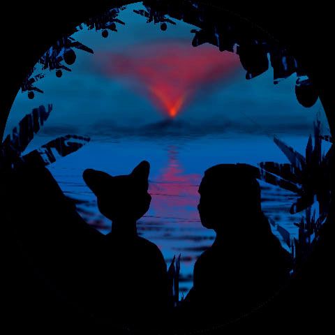
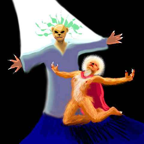
Of course, the dense air here (and slightly lower gravity) do make for easy flying; but Cytherean culture quietly furthers that, in ways Terrans may misinterpret. Many species here engineer themselves wings of course, but they also tend to run slender and small, as in this catwoman, no more than 1.5m tall (5'), with hollow bones and little fat; fur makes a lighter insulation. It isn't just about heat dispersal, as in the slender people of equatorial Africa or India; it's also to keep flightweight down. Culture and climate together shape bodies themselves.
And you figured it was a fitness craze or anorexia or something. Nope. Flight!
Since this is primarily a geotour, not a cultural one, let's ignore the days you spend exploring the city. By Thursday, that is, early afternoon, you're ready to go on. You fly inland, across this strange mix of California and Italy. The land grows warmer and greener all day as you head north. You're entering Danne-Musun Forest, full of small lakes and streams, its coast all capes and islands and sounds--a place that can't quite make up its mind if it's water or land. A winterless Finland (What's a winterless Finland, you say? It's just like jumbo shrimp, military intelligence, terraformed Venus...)
Ahead looms cloudy Mt Lanig, the highest point in East Lada, though there's little competition--the whole continent's as low as Australia. Mt Lanig is rainy and mist-shrouded, catching storms both off the Antarctic and the Aino Sea to the north; but it rarely gets snow--just too low. You fly to its summit, for here, you're at a crossroads.
THE EASTERN HORIZON crinkles with mountains, silhouetted in the glare of the afternoon sun--Cape Feruk, trailing off east into the sea--but those golden isles are the ones you camerom.
NORTH, sprawling at your feet are the twin Lanig Lakes, each nearly 100 km long and fifty wide (60x30 mi). Beyond lies long Cape Reitia, marching confidently for 600 km into the Aino Sea. But that route ends on Triglava, a beautiful little rainforested island with no flyways but back the way you came.
OVER THE NORTHERN HORIZON lies Zimcerla, a great peninsula shaped like an anorexic rabbit 750 km long. The rabbit's tail is warm, its belly hot, and its ears steamy--and head to toe, it rains constantly. The low north-south ridges of Zimcerla are covered with dense tropical hardwood forest. You could follow those ridges right across the Tahmina Sea, for unlike the Reitia ridge, these have stamina--they re-emerge as the Copias, two narrow islands each nearly 200 km long, arranged like a T. These pleasant little Polynesian islands (little for Venus, I mean!), warm, lush and ringed in coral, are the flyway to central Aphrodite. But that's another tour.
DUE WEST, the mouth of Mugazo Gulf has fields and scattered oaks. There, Cape Ambar-ona and a line of islands lead west across the mouth of the Gulf. Both cape and islands are low, with gentle hills, a quilt of woods and meadows. They'd make a pleasant, safe shortcut (even for non-natives like you) to the Shiv-Amashe Peninsula and Lake Loo-Wit...
No, let's stick with mainland Lada. A day's flight northwest is the Oshumare Strip, a land-bridge of rainforested mountains above the shore of Mugazo Gulf, a shallow bay 1000 km wide, dotted with islands, and shaped like a stubby hand with many finger-fjords. Mugazo floods the whole center of East Lada, like Canada's Hudson Bay, but more so: one western thumb of the gulf nearly links with the Aino Sea to cut poor Lada in two. The isles and shores of the gulf resemble Italy or southern France: fertile, moderately rainy, mild temperatures. A few northern bays have subtropical rainforest; most have open woods.
So you fly northwest through sunset (behind you, to the east) and the long dim polar dusk, lit only a few hundred times brighter than full moonlight on Earth... for here, most of the equatorial rings are hidden. Colors are still clear, of course, but the planets can be seen, and even a few stars, when the clouds allow. This land's as humid as the Amazon; herds of little rainclouds sweep over the green land like sheep.
Not long after nightfall, you climb a ridge higher than anything since the Oshumare Mts trailed off into the jungle... Over the top--and the green quilt falls away. A chasma yawns before you: Geyaguga. The lake-bottomed rift leads west, but soon curves a bit south. You climb the northern wall, puffing a bit--it's hot and humid even now, days after dark. Over the ridge is a second chasma, Xaratanga. It leads due west. You glide for hours down East Xaratanga Lake.

At last, a great junction: the chasma curves south to join the Mugazo Gulf: the "lake" in the distance is probably a narrow brackish sound 400 km long (though it may be a true lake draining almost directly into the sea). Ahead, the west branch of Xaratanga climbs into hills. You follow the northern ridge, gazing off to the north; to the flat horizon it's a flood plain buried in gigantic trees: Marzyana Plain.
We won't detour, though the cultures of the rainforest are worth it--but I've written elsewhere of tree-inns (sentient trees who grow cafes at their crowns), avian treetop villages and freshwater dolphin singers, bonobo free-love communes and lakeshore stilt-villages built by lemurs...
In the west, the Marzyana Plain ends abruptly in Kuldurok Scarp, a stairway with green carpet and redrock risers. The cloudwreathed Kuldurok Mountains march north for hundreds of km, trailing off as Cape Kuldurok into the warm Tahmina Sea.
Straight ahead, the mountains reach a climax as the Kulduroks meet the Asiaq Range to the northwest and the Loo-Wit Mountains to the south. This knot, called the Kshumay Mts, is the highest range you've seen on Lada so far, rising above the clouds. But probably not high enough for snow--Kshumay is still on the edge of the torrid zone. Pale meadows and altiplanos cap the Kshumays. Off to your right, just poking above the horizon, are a few white cloudy specks that don't move--the snow-streaked peaks of the Loo-Wit Range, 250 km away, no higher than the Kshumays, but getting storms from the cool Antarctic Sea, not the steamy Tahmina.
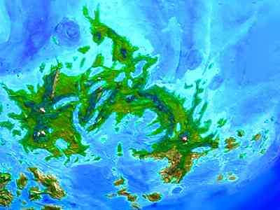
You fly patiently over the dark-wooded Kshumay Knot for two hours, and then... just when Lada's finally looking truly continental, it drops abruptly into a turquoise coral sea. Islands everywhere--little, big, gigantic. The Central Ladan Archipelago, the size of Indonesia, sprawls from the torrid zone to the pole. This is a whirlwind tour, so we'll only visit the major islands.
LADA: THE CENTRAL ARCHIPELAGO
The first few hundred kilometers are uncertain--the radar scans here are blurry. A maze of land and water, low and undulating--but how much land, how much water, I can't be sure. Then, a sharp rise to solid land: Ekhe-Burkhan. At least, that's the official name. This warm, rainforested island about the size of England is locally called Icky Burpin--Icky for short. It's much prettier than any version of its name, at least if you're sensible and view Icky by air, landing atop the tree-canopy, where all the flowers, fruit, and animal life are--much of it nocturnal, since days here are so hot. If you can't fly or climb trees, Icky'd be a stuffy, humid, gloomy trek under 500 km of unbroken forest. But it's lovely on the wing.
Near midnight you reach the western shore of Icky and look out at one of Venus's greatest scenic losses: the Ubastet Fluctus, where once a black dragon twisted--an intricate lava flow over 1200 km long, curling around mountains and ridges in its fractal path. All drowned, now--the Gulf of Ubastet.You sleep in a treetop nest, 100 meters above the sea-cliffs. You cross the gulf of the lost dragon, island-hopping for a night and a half, the darkest night, when Venus's shadow hides most of the rings, and a few stars come out.
You sleep on a great ridge rising from the sea--Ubastet Island. When you wake, a dim red light on the western horizon suggests dawn--but it's two days too early. It's all that lava's source: Mt. Ammavaru, a tall tholus (volcanic cone) on a long, narrow island. A flickering, inverted cone of dull red light--lava glowing on an ash cloud above? Ammavaru may be active--one of the few live volcanoes outside the Hot Triangle on the far side of the world from Lada.
 Ubastet, where you're standing, is an island ridge 300 km long. It's Amazonian rainforest on the western slope, opener, drier forest on the east, with fernbrakes and cloud forests on its misty heights. On Terra, it'd be a national park; but you're drawn like a moth to that volcanic light! You grab air and you're gone.
If the mountain's not gone--Ammavaru may have blown itself up. Lava that stayed liquid for 1200 km when Venus was hot may be a lot thicker in today's cooler conditions. And seawater mixed with thick lava is a recipe for explosions. Ammavaru's steepness suggests it's less Hawaiian than Krakatoan... so perhaps we'd better steer round the volcano, fascinating though it is, and land first on the coast north of it: the Isle of Astkhik.
As you beat quietly across the gulf, Astkhik is invisible at first, below the horizon. A green line appears... and grows taller, and taller, rising atop a red layer until the nearing island towers over you. For Astkhik's east coast is a cliff a thousand km long, the Vaidelute Rupes, dropping into a deep azure rift offshore--not Venus's usual shallow waters. The turbulence and upwellings along the cliff-foot bring nutrients to the surface--the water flashes blue, white, and green as bioluminescent creatures chase each other, like tiny meteors.
Astkhik's name is notorious--it's invariably pronounced Ass-Kick. Ekhe Burkhan, Astkhik! If he could, Schiaparelli (who named the features of Mars so beautifully) would certainly kick the Venus naming-committee's collective ass. But cheer up! Terraforming is slow, and by the time people settle on Asskick, those who named it for an Armenian love goddess without ever saying her name out loud will all be safely dead and immune to mockery. While they were scraping away at the bottom of the goddess barrel, why didn't they name something Hukkle, after the Hungarian goddess of hiccups?
Having labored to crest the Vaidelute Cliffs, you find the rest of Astkhik's a jungle flat as a plate. You veer slowly south, until the volcano's glow swells and reflects in the channel between Astkhik and Ammavaru. The volcano's main flows have been drowned, but it's managed to build up a twisting island 250 km long. Let's give the naming committee some credit--welcome to Hanghepiwi! It's pronounced a bit like "hang happily" if you're morbid, or "honky peewee" if you're merely obnoxious. Either way, it's good for a laugh.
Unfortunately, the locals insist the volcano is too active to fly over, or even near. So you cross to Hanghepiwi some kilometers west, seeing it from three sides as close as you're allowed. Sorry. I'm not skipping it to be mean--the data don't leave me sure just what you'd find.
It's time to detour onto the Lada group's only real continent--West Lada. From Hanghepiwi, you fly west, over a sea that looks empty. But twenty miles out, a green coast heaves over the horizon. And keeps rising. And rising! The forest caps red and black cliffs rising from the sea.
At first Cape Sarpanitum seems like the Vaidelute Cliffs all over again, but then you start to notice narrow, straight fjords lead inland, eventually becoming jungle-floored valleys laced with waterfalls. You're seeing tessera--a mosaic of mesas. Here, they're near sea level, so cliffwalled islands pave the sea like stepping stones. The valleys inland are steamy even now in the predawn cool. Once the sun's up, it'll be just too hot to fly in. So you cross the cape, skirt Sarpanitum Bay, and head south along the Lhamo Peninsula, into cooler country.
Lhamo is a steadily widening wedge of pleasant land stretching some 800 km--tessera in the north, calming down in the south. The woods open up; you even spot a few meadows. Hills begin to rise, just as the sun does. You veer east, away from the glare--the Central Archipelago still has sights to see, before you explore continental Lada. At 58 south, you head offshore, over an islet-dotted sea.
Ahead is a glowing pink snowcone in the dawn sky--Mt. Ndara, tall enough to be snowcapped many nights and mornings. At its feet is Chang-Xi. A twisty ridge of pleasant subtropical forest wrapped around a coral lagoon 50-100 km across, Chang-Xi is still warm and rainy, but not a jungly steambath like Astkhik or Cape Lhamo. It's shaped like a horse trying to do a back-flip... a horse with a pimple on his butt two miles high. As on Bali, whenever you're feeling lost on Chang-Xi you look for the mountain--the pole of this little world (though anyone who grew up in Portland or Seattle knows the feeling too; you look for Mt Hood or Rainier for guidance, it's instinctive.)
200 km off Chang-Xi's eastern shore lies Otygen (not oxygen, Otygen)--either a pair of islands that fused, or one gigantic island with a split personality. North of the narrows is Otygen Corona, a hilly round pillow 400 km across. It's warm but not hot, with woods and fields along the coast and forests in the hills. Nothing spectacular here except the coastal cliffs--just a pleasant place to live.
But the southern lobe of Otygen Island, called Cocomama, has tessera like Cape Lhamo--sea-cliffs and red mesas, with forest on top and in the canyons. It's like a fossilized Manhattan overgrown by jungle--but a city the size of a small nation, an irregular squiggle over 500 km across. Most tessera on Venus ended up in deserts, smothered in jungles, or drowned undersea. Cocomama is one of the prettiest survivors. It's popular with many Terrans and Martians, who feel stifled by the humid heat of Cape Lhamo.
From Cocomama you fly southeast to the low island of Tsects, then on to Toyo-Uke, a low J-shape 600 km long, and quite Californian in climate, with mild sunny days and night fogs feeding redwood groves in coastal valleys, but oak savanna and vineyards inland. You're 65 degrees south now, and beginning at last to feel the cooling, drying influence of the pole.
Okhin-Tengri is next--now you're past 70 south. Okhin-Tengri's shaped like a seasick sperm swimming north--a round corona, trailing a long crooked tail toward the pole. Even now, near noon, it's cool and foggy. When the sun breaks through, it's low and reddish. Most of the sparse rain falls at night, nourishing sparse drip-forests on the coasts (some conifers can harvest water from fog), but only brush and scruffy grass inland (though there isn't much inland, inland--most of Okhin-Tengri's a single rocky ridge wandering through the Antarctic Sea).
Last of all is Su-Anasy--the southernmost large land on Venus. It's 500 km wide, and if you crossed to its south shore, you'd be just nine degrees from the pole. It too is cool and dry--fogs, but little rain. Su-Anasy is grassy but nearly treeless, except a few sheltered northern valleys. You shiver in the cool wind on the shore, and as you realize it's high summer here--as hot as it gets--you shiver more. A lonely, melancholy place, unless you're one of the millions of nesting seabirds.
Still, it's alive! Think of the icy wastes of polar Earth or Mars, and you'll appreciate the miracle of Venus.
We could get even closer to the pole, via little Obilukha and the islets beyond, but it's all like Su-Anasy--and a dead end. Let's backtrack up the chain to the Mediterranean zone. A waste of daylight, I know, but you can't cross to West Lada here--the gulf is just too wide and deep--not a single rock for a halfway roost. So you plod back up Okhin-Tengri to its head, and only then veer off, over long, low, grassy Seo-Ne, and sleep at its northwest tip.
WEST LADA: THE BIG LAND
When you wake, the sun is nearly setting. You leave the whispering prairies of Seo-Ne, golden in the late sun, and head due west over the sea. A promontory appears, ruddy in the low light. West Lada! The coast here is cut by narrow, deep canyons, continuing undersea as deep blue stripes, gaps in the green-brown-purple kelp forests.
Dusk is relatively peaceful tonight--no flaming cloud castles. Just warm light from the east, fading, and white light from the rings to the north, growing. The land below is mixed forest and meadow.
Slowly a strange ridge in the south converges with your western path. The ridge looks huge, and weirdly even. It's the edge of the Quetzalpetlatl Highlands, the heart of West Lada. Qetzalpetlatl is a round plateau 1200 km across--like a giant pancake. Well, a thick stack of pancakes--Quetzalpetlatl's 2-3 km high. You're in shadow, but it still glows in sunset light far above. The high points on the rim see frost every night, and often snow--the only snow-country in Lada. The slopes of the plateau are abrupt, and wring rain from the coastal winds, creating a ring-forest of pine and aspen. In contrast, the plateau is dry, mostly a high desert of rough red lava rock with ridges of sparse, slow-growing ponderosa and spruce, with occasional pothole lakes and marshes. The plateau blocks some southerly rains from this region, though most storms here come from the northwest, off the Lavinia Sea.
Now, ahead of you, a second unnaturally even wall rises, much lower then Quetzalpetlatl, and a mere 100 km across--so small you can see both ends retreating over the horizon in a visible arc. It's the rim of Alcott, a huge impact crater. These northern, outer slopes are wooded, but let's ride the updrafts over the ridge. Inside is Lake Alcott, a shining blue disk 80 km wide. The rimwall's inner slopes are mostly grass and brush, just bare smooth rock in places--smoky, translucent impact obsidian. Alcott's sunny beaches are wildly popular with Ladan vacationers, for the crater gets less rain than most of West Lada, partly due to Quetzalpetlatl, and partly from another influence just over the horizon:
To the northwest is Mt Tarbell, near the shore of the Lavinia Sea. Tarbell catches so much rain it's mantled in temperate rainforest, and its rainshadow downwind keeps the cliffs of Alcott Crater and the beaches of the sunken lake one of the driest, sunniest places in Lada. Even now in early evening, the water's warm. You swim briefly, then watch the local creatures sun, read, play and swim until you fall asleep. Don't worry. In Venus's thick atmosphere and the low angle of that warm sun, you won't burn.
When you wake, you head for Tarbell, which commands the best views in West Lada. It's below the horizon for the first couple of hours, and grows slowly for another two. It's evening now, and the rings are at their brightest, showing more rolling, gentle country, meadows and groves and winding streams, turning drier and grassier near the mountain where the rainshadow's stronger. You swing round the mountain to the upwind side and ride up the easy way.

It's oddly disappointing. People love stories that they wouldn't want to live in--tales of catastrophe and extremity. And the tourist's eye feels the same about landscape--this, one of the gentlest regions you've seen, certainly the friendliest for unmodified humans, interests you less than the stony barren heights of Quetzalpetlatl did--they were dramatic. Craters, volcanoes--is it violence or mere drama we crave?
Sulking, you storm down the mountain, stooping like a hawk to the shore of Nike Bay, at Tarbell's foot. Sleep on the beach and then, impulsively, head out to sea, tired of this bland land. You can't see a thing ahead but silvery water and small coral reefs, perhaps the southernmost on Venus--the sheltered bay is warm for this latitude. It's two hours before you spot land ahead--Cape Penardun, the peninsula sheltering Nike Bay, a good 500 km long, sticking north into the Lavinia Sea. Its tip is due west of Mt Tarbell but it was too far offshore to spot, even from the summit. It's rockier and more scenic than inland, but here too the climate is mild, supporting broadleaf forests. It's all about as Terran as you can get, on Venus.
You fly down the cape, looking for Venuosity, and not finding it. All through Yule, the dark time, you head south, even when you reach the mainland. Below, it's still that pleasant green... maddening.
At last the land starts to heave uneasily and the snowy rim of Quetzalpetlatl looms over the eastern horizon. The plateau's sheer weight has caused a slump at its foot; ahead of you, this has filled to form Lake Naijok, one of the largest on Venus--a zigzag of a lake, a good 1200 km long--half the size of the Caspian. Its shores are cool, mild, and generally fertile, but with bare red cliffs and bluffs where the slumping land's fractured and tilted up. It's only a faint echo of the rough, dry country found in the Highlands just to the east--these cliffs, mirrored in the lake, have woods and meadows at their feet. Naijok is no desert--but at least it's rugged.
You contemplate a side trip east, up on the plateau, but that's a lot of work! Thin air makes for hard flying. A compromise might be to visit Mt. Boala: a wide, massive, snowy mountain, a sort of tongue sticking southwest from the main Quetzalpetlatl highland. The mountain's named for Boala Corona just northeast, on the south edge of the plateau, and one of its highest points. The slopes of Boala squeeze rain from the coastal winds, creating an arc of dense dark forest, thinning to alpine meadows. The summit has snow patches, but is too dry and windswept to accumulate a deep snowpack and grow glaciers. The inland side, linking it to Quetzalpetlatl, is a narrow red stony desert with lonely, windblasted pines.
It might be worth it to meet the bears. Quetzalpetlatl is the homeland for grizzly/brown bear culture. With nearly chimp-size brains even in ancient times, it didn't take much engineering to push them over the top into sentience. We won't explore their salmon-fishing culture, so like the Northwest Coast tribes before them, with their longhouses and totem poles and epic masked dramas about mythical trickster beasts like Raven and Human, during the long dark ringless nights...
But Boala too is a full night's flight east, and you're feeling impatient. West for you, away--you're near the end of Lada. By early Witch, as the ringlight peaks, Kamui Corona is rising ahead of you. Kamui has a bulbous central range between two slender, flanking, arcuate ridges, with cliffs on their inner faces dropping into lakes--the outer ramparts of the corona. On a map, it looks like the yolk and shell of a cracked-open egg. From the air, it's simply beautiful. Stately, somehow elegant land. Cool, foggy in places, but rarely rainy in the day, Kamui resembles the central California coast, with small redwoods along the coastal cliffs and bay laurels and oaks further inland. We're on the far side of the world from New Frisco Bay, but ecologically we've come full circle. Mediterranean climate on Earth is rare, found in scattered patches--but Venus has two wide belts of it, all the way round both poles. You sleep on the south arcuate ridge, atop a cliff overlooking the Antarctic Sea.
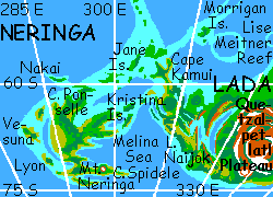
NERINGA
You wake in predawn light.
Lada is narrowing fast, as you glide west along the south shore, riding the cool winds off the polar sea, which leap up the cliffs and form foggy tongues below you. The coast breaks into blunt capes and bays, angling northwest, and you follow, riding the updrafts, face toward dawn. Which is odd, though you probably didn't notice, not being a native Cytherean. You're flying fast toward the sun--probably faster than Venus is turning, at this high latitude. Dawn should be speeded up.
It's not. The reason is, it's not Dawn yet by the calendar--just dawn in the sky, far earlier than normal. The sun here rises at such a low angle, it's barely below the horizon for two full Earth days. So the rings remain bright (what little you can see of them, this far south--just a white dome on the northern horizon) and the bluegreen glow in the west teases and increases, slowly, all day, or night, I guess we should still call it.
And then you're there. You see water to the north, too. You're on a neck no more than sixty km across, a green thread in a predawn sea. Ahead, it widens again to a wall, and you worry you have another corona to cross--but it too is a narrow ridge in the sea, a crossbar on the cape, which breaks up soon after, in a hodgepodge of islands and rocks, trailing off (as you know from maps) all the way to the continent of Themis, 1000 km northwest.
But here you notice something else that jogs a map-memory. A second island-trail leads southwest, and though you can't recall its name, you recall there's a little-visited land out there. You decide to fly until sunrise, the hour you began this four-week trip, before quitting. See if Venus can surprise you.
You recalled right. You hop from isle to isle, curving slowly southward, and the Jane Islands just grow and grow. The same rise that created West Lada re-surfaces as Neringa, three times the size of Greece, and resembling the Aegean in climate and even geography--a great maze of sounds, capes and islets, though less mountainous than Greece.
You even nap, and wake to find it's true Dawn now--no sunrise yet, but a hot glow in the sky behind you. Only you're so close to the pole now that following Neringa south and then east means you're fleeing the sun faster than it can rise!
Caught in a dreamlike, perpetual dawn for hours, you zigzag along narrow ridges running hundreds of kilometers into the polar sea. It's eerie, beautiful country--long ridges, cliff-edged, between azure deeps. You'd expect just grass and rocks, but Neringa gets California-like fogs as well as light rains, supporting redwoods in coastal valleys, inland meadows studded with groves, and dark pine forests on the ridge-heights. When you land to rest, you feast on wild berries. The mid-sea ridges force deep water up, so the sea, too, teems with life--rich kelp forests line the shores.
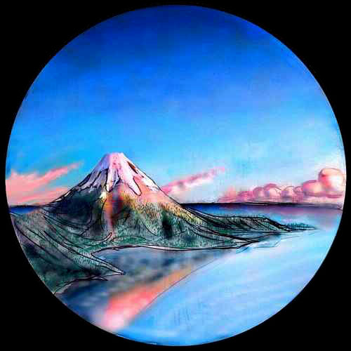
Ahead, a beacon looms. A volcano rising from the sea at the tip of Neringa's final cape, barely a sandspit--like an Aleutian island on a leash. The beacon's on fire--so tall it reaches into the daylight you've been fleeing. A mile high, two miles? Streaks of rosy snow at the top. You beat into the wind, up the face of it, exhausted, stubborn, reckless. You burst into daylight and catch fire, glowing as if your maker just pulled you from a forge. Below, the green and tawny capes and islets are small as reefs, the deep bays and sounds like tidepools.
To the south is dark sea, not only untouched by sun, but out of the rings' reach too.
And out of that dark nothing grew this pillar of light! Something from nothing. That's how it's done! That's how Venus was done. A mad idea, a spark in the void.
You've reached the end of Lada--or, if you have the eyes to see it, the burning beginning of the world.
FACT AND FICTION
Mt. Neringa, for example, was named in desperation. There wasn't a single named feature within hundreds of km--not even a nearby drowned crater whose name I could steal.
Ammavaru's an exception--an older name that's not in the current NASA/JPL database. I'm retaining it because I like it.
Oh, and Hukkle isn't really the Hungarian goddess of hiccups. At present, that job is empty. Hukkle is Hungarian for hiccup--and it's the name of a very good film. Not a goddess, just a movie, OK?

World Dream Bank homepage - Art gallery - New stuff - Introductory sampler, best dreams, best art - On dreamwork - Books
Indexes: Subject - Author - Date - Names - Places - Art media/styles
Titles: A - B - C - D - E - F - G - H - IJ - KL - M - NO - PQ - R - Sa-Sk - Sl-Sz - T - UV - WXYZ
Email: wdreamb@yahoo.com - Catalog of art, books, CDs - Behind the Curtain: FAQs, bio, site map - Kindred sites