THARN
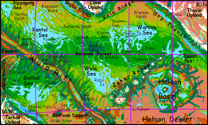
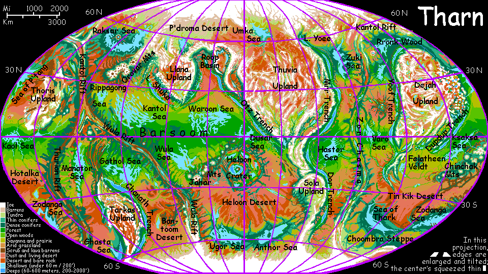
The Barsoom Basin
by Chris Wayan, 2005-6
Map, Tharn's homepage, Peoples of Tharn, Regional tours, Geology and Evolution, gazetteer, terms explained. More worlds? Planetocopia!
INTRODUCTION
The Barsoom Basin is an equatorial region of seas and forests--the wettest region in the world. That's not saying much, of course--if this were Earth, Barsoom would be an ocean, brim to brim. Instead, the "sea floor" is just a great plain, with salt lakes at the low points. These are rarely over 100 meters deep, and usually less. And yet... the Kantol, Wula and Waroon Seas are puddles by Earth standards, but their surface area is enough to guarantee that any wind brings at least some moisture. And the equator, heated by full-on sunlight, is a zone of rising air; as the air rises it cools, generating clouds... and, often, rain.

The Pacific Ocean has trenches and island-arcs around its edges and a rift zone in its heart, as well as the most prominent example on Earth of a shield-volcano chain: Hawaii. The Barsoom Basin is startlingly similar--except all these features are laid bare. Chains of great shield volcanoes rise twice as high as Everest; a rift meanders along the west side of the basin, where new crust spreads, forming a long winding fracture zone of rugged, wooded ridges. Mountain-arcs cut off basins of desert and steppe around the edges. Most importantly, "continental" uplands end in rugged coastal ranges, dropping into subduction trenches many km deep; the trench floors are usually flooded, but the lakeshores form oases where the air is dense and mild.
In the early 20th Century science fiction writers like C.S. Lewis pictured Mars as a desert world scored by deep gashes (the canals) where water, air and life collected: linear oases. The trenches of Tharn are quite similar. Air pressure out on the plains is comparable to the summit of Everest; but in the deepest trenches, it's merely Alpine--breathable even for Terrans.
All this is quite Martian. If the Red Planet had a bit more air, you could stroll in Mariner Canyon and Hellas Basin, yet suffocate out on the plains. Small worlds with low gravity tend to be quite vertical, and verticality leads to big air-pressure variations. True, the air thins out slower with altitude (an effect of low gravity) but overall, both Mars and Tharn have a wider range of surface air-pressures than Earth.
And yet... if you drained our seas as dry as Tharn, revealing Earth's true ruggedness, Everest would rise nearly 20 km (about 65,000') above the Mariana Trench. Air pressure would be nearly 5 atmospheres down there, 1.5 on the abyssal plain, two-thirds normal in the ruins of New York, barely breathable in the Alps and Rockies, and nearly Martian atop Everest. A very Tharnian gradient! So it's not really small size that gives a world a wide air-pressure range, but aridity... exposing its depths, not just its heights.
With that in mind, let's tour this vast abyssal plain--the biological heart of Tharn.
WESTERN BARSOOM: KANTOL SEA
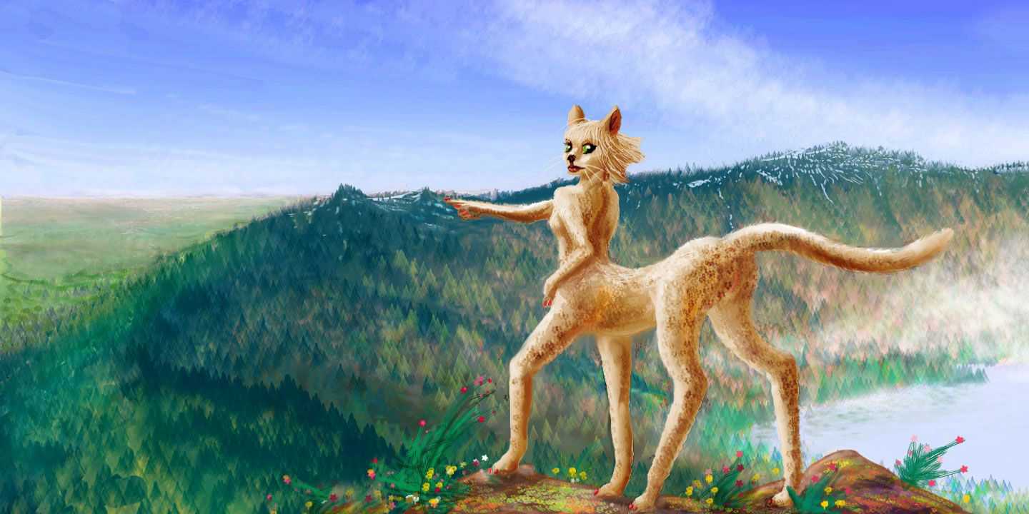
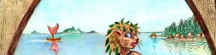
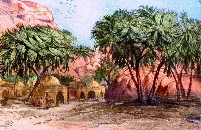
Southwest of Llana Upland lies a fertile region: the Kantol Sea, biggest on Tharn, fully 2500 km (1600 mi) long and 1600 km (1000 mi) wide. I admit that Kantol's shallow and broken by endless islands; except for its heart, it's more of a marshy maze than a sea in the Terran sense. But it's rich country with diverse niches sustaining many intelligent species. Thotters live on these fertile islands and fish the waters, even building raft-houses where natural islands are lacking. Scaly bos, elegant centahs, playful veltaurs, childlike plains wingbok and the occasional flyote tribe all share these shores.
The north end of the Kantol Sea is a labyrinth of sounds and low ridges, all trending northwest-southeast, called the Repseen Maze. It's about 1300 km long and half as wide (800 by 400 mi). The climate is quite Mediterranean, with groves on the ridges and tree-lined rivercourses, but brushy hillslopes and rocky coasts.
Kantol is relatively deep and sealike at its west end, but to the southwest it breaks up into Thioma Maze, another labyrinth of channels around Cape Thioma. The cape zigzags 400 km into the sea, but the tangle of islands and sounds stretches a good thousand km east along the shore. The sub-equatorial climate supports open forest with some meadows and brush.
West of Kantol, it's a thousand kilometers to the Rippagong Sea. The golden plain between, called K'lantha Veldt, sprawls like a centah in the sun. Long east-west ridges (the last gasp of the fracture zone around Wula Rift to the south) break the grassy plain, forcing all the streams to run parallel. The ridges often have redrock scarps on the north side, giving K'lantha a desert-mesa look that's deceptive; storms can blow in off either sea, so rainfall's fairly reliable as Tharnian savannas go. It's too open for tree-loving bos, but veltaurs farm along streams and centahs herd flocks on the plain.
WESTERN BARSOOM: RIPPAGONG
Beyond K'lantha is the Rippagong Sea, a salty little lake only a third the size of Kantol. Distant from the other seas and from the equatorial rainbelt, Rippagong's shores and islands (such as huge Pshika) get less rain. The climate's Mediterranean, with meadows and brushy slopes; trees cluster along streams and on cloud-catching heights. Centahs and veltaurs herd flocks on the hills and irrigate the bottomlands.
The seashore and the Pshika Islands are dotted with thotter villages. It's too salty for traditional thotterian aquaculture: waterlilies and herds of parru just won't flourish here. But the fishing is good, and they trade the excess for greens and fruit from the local centah and veltaur farmers. Since this trade is all in perishables, it's constant and local; the communities are tightly interknit.
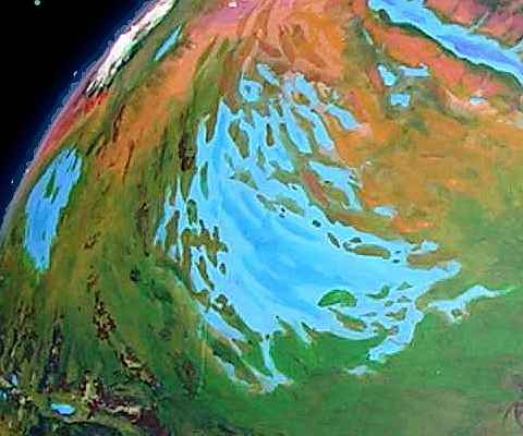
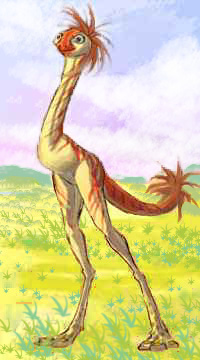
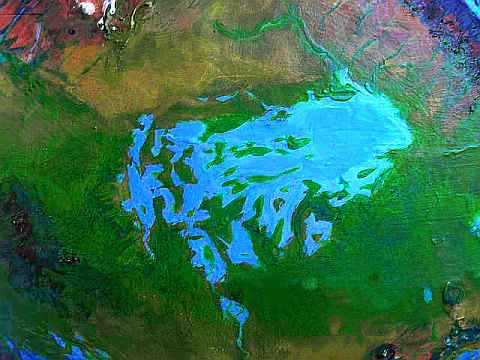
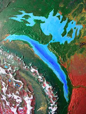
Northwest of Rippagong, the Barsoom Basin ends in the Tlani Desert (upper right of orbital photo), a triangular plain twice the size of Texas. Tlani is broken by streams running down from Mt Gholit, a shield volcano 16 km high (50,000'!) and from the ridges of Kantol Rift to the west, but water is scarce. A few herds of small, childlike plains wingbok graze the red plains, and a few villages of flyotes farm the river canyons, but it's lonely country compared to the green shores of Rippagong to the south.
We've gone far enough--so far, in fact, we're in such a hinterland we'll have to retrace our steps. Back south over the dusty plain, hitch a ride on a trade-boat along the west shore of the Rippagong, then back over K'lantha Veldt, veering south this time, along the foothills of Wula Rift. This is big country--at a typical caravan pace, it's going to take us weeks to return to the shores of the Kantol Sea! Why don't we start over, and just deny we ever went west? In fact, I think we'll just keep on cheating and taking one-way side trips. Barsoom is just too big to explore in any sane, realistic fashion... so...
WESTERN BARSOOM: HURUFAI
Poof! You're standing on the south shore of Kantol, oxygen mask on, walking stick in hand, hiking inland, up a winding river valley--forested ridges, meadowy bottomlands--farmland, in fact. Herds of ostrich-dino-roo things called losha graze the slopes and meadows; centah shepherds keep a close eye, to prevent straying into fields of green pods and reddish fruit, tended by veltaurs. When you eat some in a cafe that night, you dub them "tomatoes" and "stringbeans"--if tomatoes tasted like hickory-smoked red wine and stringbeans like pickled pumpkins. Losha eggs aren't chicken eggs either: rubbery, green, and tasting like shrimp. Losha yogurt, though (yes, they give both: lay eggs, then feed the hatchlings milk) isn't too different from the Terran stuff: sugars become acids and sour is sour. Though you didn't expect it to be pink.
Two weeks later, nothing's changed a bit! Fields, farms, river, ridges, good if peculiar food. You've moved half an inch on the map. I think it's time to bribe some thotters to tow you upstream. They can swim a lot faster than you can walk.
Even so, it's several days before we reach our next stop--not that you recognize it at first. The ridges around you have been growing for days from gentle humps to respectable mountains--the edge of Wula Rift. Now the river you've been riding up forks; between the arms rises a curving ridge or scarp, "pine"-clad. It's time to leave the valley and climb. Enjoy! You can't wimp out on me, claiming shortness of breath--your oxymask feeds you five times what the local centahs get. If they can do it, you can...
By the next morning you're nearly a mile higher and much sorer. Cheer up! Your mask kept you alive. You're high enough now to die without it, not merely faint. You've climbed out of the atmosphere--by Terran standards. Tharnian life disagrees, of course: a healthy evergreen forest surrounds you.
You top the ridge at last, expecting to find either a hell of a lot more ridges, or a long dry canyon: Wula Rift itself. Neither!
The huge, perfectly round basin below you is Hurufai Crater, about 65 km (40 mi) wide. It's pronounced like "a roof-eye", not "horrify". Lake Hurufai fills most of the floor, except for a craggy central island. The whole thing looks quite lunar, only painted blue, silver and forest green! And dusted with white, atop the highest bits of the ringwall--evidence of a rare snowfall, though we're not far from the equator. Lake Hurufai lies in fresh crust so close to the rift that it can't be over 10 million years old. The impact must have devasted the southwestern Barsoom Basin, making it truly lunar. But the region gets such high rainfall that it quickly recovered; it's as lush as anywhere on Tharn.
Let's cheat again to save a week, and NOT raft 800 km back down the Hurufai River. Reset button!
WESTERN BARSOOM: REPSEEN AND ESHAREE
Poof! We're back at the southeast end of Kantol Sea, sitting on a thotter trade boat heading east. Puffy clouds break up the deep Tharnian sky, silvering the shallow sea with reflections and dappling it with slaty shadows. Ahead on the horizon rise dusky green-violet hills: the Kyo Archipelago. These eight low, hilly islands are up to 200 km long (125 mi). Tropical forest covers most of the Kyos, for we've reached the equatorial zone (by cheating, yes, but here we are). To the south and east of us stretches Barsoom Wood--we hiked through the fringes on our way to Hurufai Crater.
It's the largest forest on Tharn by every measure--size, density, or diversity. No mystery why this region of Tharn's almost Earthlike! It straddles the equator where hot air rises, generating storms, and three great seas surround it, feeding water vapor into that rising air. These almost-rainforests are the home of an odd species called bos, the only one of Tharn's dozen-plus peoples comfortable in tropical forest (though mops do well in cooler woods).
From the Kyos we sail to the northeast shore and head up into a second great savanna, Esharee Veldt, home of veltaurs as well as centahs. Barsoom's groves thin out slowly but steadily: Northern Esharee is dry grassland, with trees only along branches of the Obilla River. These odd streams all run parallel, down straight canyons called fossae--cracks opening between mesas as the crust warps a bit outward, before diving deep into Shuka Trench at the edge of Barsoom Basin. In the sketch, the trench itself is still hidden behind the hills, but the Shuka Range beyond is quite visible, though it's a good 300 km away. Yes, they're that tall!
These mesas and arroyos look like erosional features of a semi-arid land, but a deeper process is at work--miles deeper! We'll soon be seeing nearly identical landforms in a rainforest. Nor are they unique to Tharn: our seafloor off the Andes, Aleutians and Java has similar ridges, though any fossae are filled by ooze. Fossae from outward bulging are common around the Martian uplands, too.
In contrast, as we return over southern Esharee, it seems so gentle: the cracks heal, the grass grows lush and groves dapple the open plain, even away from streams. The south edge of the veldt's a patchwork of wood and meadows, rising into the densely wooded Madhu Hills--part of Barsoom Forest.
EASTERN BARSOOM: THE WAROON SEA
The Waroon Sea, in eastern Barsoom, is nearly as big as Kantol. All its shores are wooded, for it lies almost entirely in the equatorial rainbelt--which it helps create, of course. The east end of Waroon is one of the largest unbroken bodies of water on Tharn--a featureless sea 500 km across (300 mi).
Still, Waroon's north shore is drier than the south; away from the water, the woods quickly thin to a savanna bigger than Texas and drier than either K'lantha or Esharee Veldts. The only large stream is the Yola River, fed by the stony uplands of Yola Ridge, 800 km (500 mi) north. Yola's a long "dorsum", a single straight ridge 2000 km long, where two plates slip by at different speeds, squeezing slightly. Earth has much larger examples like the Ninety East Ridge south of Bangladesh, but all are undersea and little-known (well, unless you count the much-eroded Urals, and they're probably more the debris from a head-on collision between plates, not slippage.)
Anyway, on Tharn quite a few such dorsae are exposed; simple, straight, stark mountain ranges like Yola. The whole region has a drastic simplicity: the barren plain, the great ridge, all naked. The only trees are thin evergreen forests high on the south face of Yola where clouds occasionally condense. To the north is only desert; Yola's a sharp natural boundary to Barsoom.
But the Waroon coast is green enough. Let's head west along it. Soon hills rise from the sea, on the horizon--the Dziran Islands, two parallel chains 800 km long, running west all the way to Cape Kiarro. Five of the Dzirans are over 100 km long; the largest and southernmost stretches 400 (250 mi)--much larger than Crete, and greener. Not bad for a desert world! The Dzirans are warm and wooded, with thotter villages on the shores.
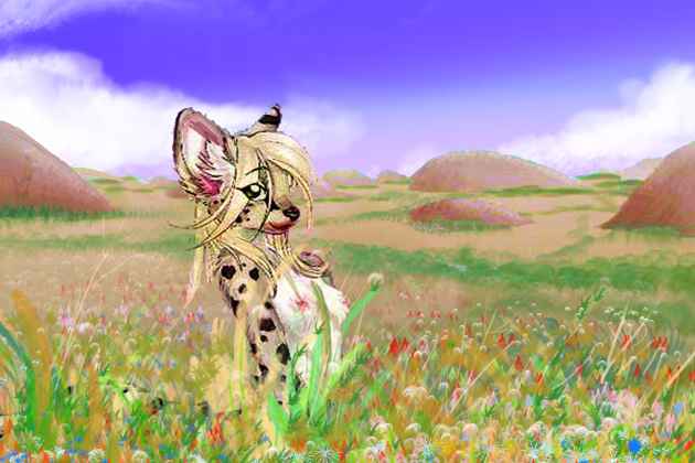
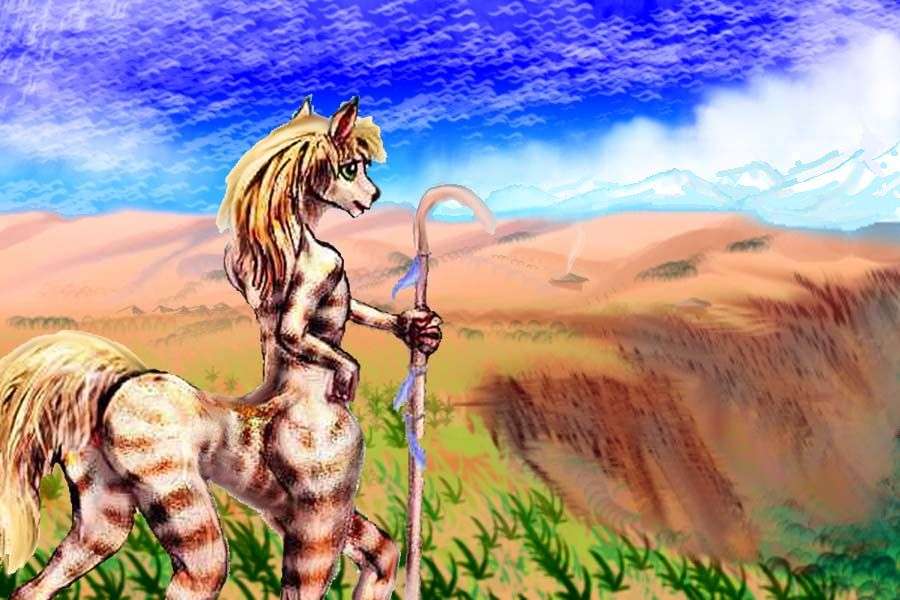
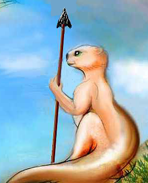
Below is a portrait of a rarity; a centah from a tribe who lives on the water, in stilt-huts, sailing boats up and down the Dzirans, trading. I say "a rarity" because nearly all water-traffic on Tharn is run by thotters; but this subspecies of centah likes water. While they can't compete at fishing with a species that can hunt a school right down to the lakebottom, they're superb boatbuilders, sailors, and navigators; and the Waroon is big enough, and complex enough, to support rival long-distance shipping lines. The very fact thotters can always jump off and swim makes their boat- and raft-building slightly careless, and their playfulness keeps their schedules equally loose; but centahs like elegance. If you're shipping perishable fruit or fussy relatives, centah clippers will get them there dry and on time (delivery guaranteed, but not temper).
To the south lies Cape Charinthe, a dense tropical forest the size of Java between the southern tip of Kiarra Arm and Charinthe Bay, a meandering sound 500 km long (300 mi) to the east.
At the head of Charinthe Bay is the delta of the Tholemaat River. The Tholemaat rises in the Jahar Range in eastern Barsoom and flows 1300 km (800 mi) north to Charinthe. Only 150 km upriver lies Lake Tholemaat, 250 by 160 km (150 by 100 mi). The lakeshores are still tropical forest, but more open than Charinthe; further upstream, the river's a wooded strip winding through wide prairies, home of veltaurs and pastoralist centahs, who trade extensively with thotters along the river. Such trade's also common on the Wula Sea to the southwest.
Back in the forest, east of the Tholemaat Delta, is Cape Larothe, a great wedge of forest similar to Cape Charinthe or Kiarro. Further east is Larothe Bay, a triangular bay 270 km long (170 mi) long--nearly a separate lake. The south shore of the Waroon Sea writhes on east for 1000 km, bay after bay, cape after cape, all lushly wooded.
To the southeast lies Lake Pshu, a marshy triangle 250 by 160 km (150 by 100 mi), due south of the Waroon Sea. The shores are unbroken tropical forest. The low Isle of Pshu, 80 km/50 mi wide, nearly fills the south end of the lake. Thotter villages line the shores; it's too marshy for anyone else, even lake-centahs.
I did warn you it's a complicated place. There's a slang phrase in Barsoom for any subject demanding tedious memorization: "like learning Waroon!" Not just more geography per square kilometer--in Waroon it seems like every square meter is another damn name.
Let's take a break from this relentless tharnography and look at the local people a moment.
ON THOTTERS
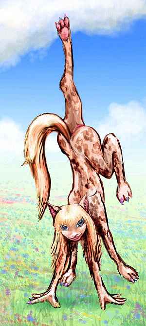
Thotters resemble Amazonian otters with opposable thumbs on all four paws, larger eyes adapted for Tharn's reddish light, and a human-sized brain. They usually walk on all fours but sit or stand upright. The large tail acts like a third leg, freeing the forepaws to use as hands.
Equally comfortable on land and in water, thotters are as vocally sophisticated as dolphins, and use echolocation in muddy water.
They evolved on the isles of a warm shallow bedlake in the Barsoom Basin (which one is uncertain). Today they're found all around Tharn except the uplands and poles--wherever islands offer fairly warm sheltered sites for their arching reed longhouses. In recent millennia they spread to many islandless lakes by weaving raft villages--in some cases, whole reed islets worthy of the Aztecs.
In modern times, as raiding dwindled and trade grew, they began building lodges on the mainland, along rivers and marshes.
Thotters are aquafarmers, traders, handcrafters. Half the Barsoom population are aquatic herders, tending parru, herbivorous semi-aquatic duckbilled dinosaurians who breathe through a sort of living snorkel--the headcrest. The crest is also a resonator--the booming honks of a parru flock carries for miles, sounding like a herd of drunk tuba players. The copious, rubbery eggs of the parru are a staple of thotter diet, and are a valued export item, rivaled only by smoked fish and lotus seeds. Thotters, unlike Terran otters, are omnivores; they also farm reeds with sweet, starchy cores, marsh grasses with oil-rich seeds, lilypads and floating flowers for salad and fruit.
Like their Terran parallels, thotters are extremely playful, affectionate, optimistic, and hyperactive.

Thotters reject organized religion. But then, thotters reject organized anything. Spirituality is visionary but egalitarian--anyone can (and many do) have guiding dreams and visions induced by wild firelit jumping-dances. These visions and dreams can be induced for quite mundane purposes, even business advice; other species accustomed to more respectful or mystical approaches to the other world find it hard not to giggle at the sight of a paint-daubed thotter dancing into trance than shrieking out their deep dilemma for the gods to resolve:
"Buy or sell?But it works for them, and they too see the humor in it--after they've bought. Or sold.
Buy or sell?
Buy or sell?
BUY OR SELL?"
The Wula Sea region is the driest of Barsoom's three great seas, for it lies furthest from the equator, in a zone of sparse rains rather like Africa's Sahel. But Wula, though shallow, is no Lake Chad growing and shrinking with fickle monsoon rains. The ridges of the nearby Wula Rift snag storms on their wooded heights, so a steady parade of rivers run east to the sea; the west shore has a major delta every 1-200 km.
The savanna between Rift and Sea sustains species like veltaurs and centahs; the river valleys, people like thotters and flyotes (where they can burrow into cliffs and high banks). The hills are far enough from the equator to see some snow in winter; here one finds small villages of mops and nomadic camaroo herders.
To the south, the land grows steadily dryer; the grasses fray like a worn rug on the fringe of Heloon Desert. Here veltaurs predominate, living in small villages tucked into fracture-zone canyons where there's water and shade. Veltaurs are playful and like novelty, but without the diversity of viewpoints from other species, the region is still a cultural backwater.
SOUTHERN BORDERS: RIFTLAKES AND VOLCANOES
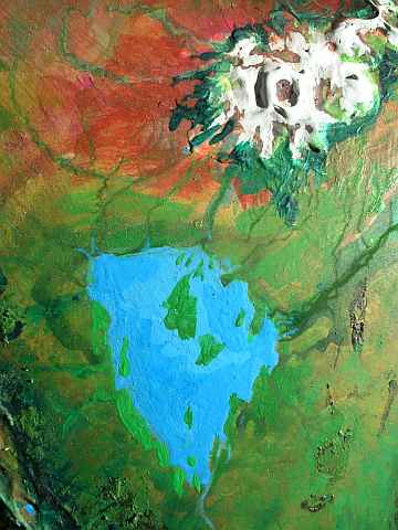
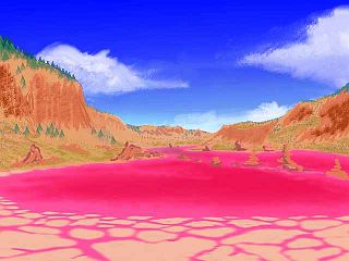
Over the ridge and down in the belly of the rift is Lake Rishish, 550 km long but never more than 65 wide (330 by 40 mi). It's a classic riftlake--brackish, mineralized, with grotesque tufa towers and pyramids on its shore and in its depths, where hot vents feed strange life forms and thermophilic bacteria stain the lake with bloody purple clots. It looks like a forge of evolution, and it is--though it's far too young to be the origin of any of the species I've mentioned, vents in riftlakes like Rishish were the birthplace of Tharnian life. Ironically, it's a barren place now: the surrounding ridges intercept all the rains off the Wula Sea, so the shores of Rishish are red desert. The lake's fed only by runoff from the forested heights; it has no outlet.
Far south of the Wula Sea is a second riftlake with no outlet, Lake Wssh, 560 km long and 100 wide (350 by 65 mi). It's not quite as mineralized, for the lake and the rift are well above datum ("sea level") at this point, and the shores are cool steppes, not desert as around Lake Rishish. It's deeper than Rishish, too, for the wooded ridges above the lake are far enough from the equator to get winter snow; the snowmelt feeds the lake even through dry summers.
Lake Wssh really isn't in the Barsoom Basin, but I don't know where else to mention it; it's a no-creature's-land between Barsoom, the Heloon Desert and the equally lonely Bantoom Desert east of Tarkas Upland. I just felt guilty ignoring something twice the size of the Great Salt Lake.
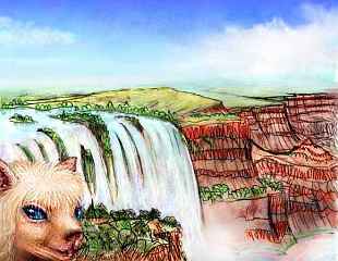
Southeast of the Wula Sea is high, spectacular country. The shield volcanoes of the Jahar Mountains are formidable peaks even for Tharn: Mt Umblam is 16 km (52,500') high and 500 km wide (300 mi), rivaling Mt Olympus on Mars. Concentric climate belts ring the great peak, from near-Martian down through alpine, forest, savanna and desert. As on Olympus, lava flows often form great terraces dropping off in scalloped scarps (cliffs) up to a km high. Half a dozen snowmelt rivers wind across these plateaus and drop up to a kilometer in massive, leaping falls. The cascades of the Umblam Terraces make this corner of Barsoom a scenic wonder, though only among those species who can stand the thin air of the heights.
At Umblam's foot, the Ruha Islands turn the eastern Wula Sea into a maze of channels. The northern Ruhas are a chaos of small, low isles, but the southern Ruhas are dominated by twin islands both 400 km long (250 mi) but rarely over 50 km wide. They're almost certainly old, broken lava flows from Umblam, longer than whole Terran nations.
The lava makes for rich soil, and the Ruhas have a Mediterranean climate. Thotters aquafarm the shores and shallows, while veltaurs herd and farm in the hill-groves and glades. Since one's semi-aquatic and the other's adapted for dry veldt, these species usually can't mix much, but the convoluted shores and islands of Wula and Kantol Seas give them a rare opportunity. Under the skin, the two species have surprising parallels--optimistic, social, and playful (to the point some species dismiss them as never-serious).
These days in Wula the two peoples trade so extensively that linguistic and artistic borrowing makes it hard to tell just who invented many artifacts, songs, slang terms and dances. Visual art is distinguishable only for physical reasons: thotters see further into the blue/violet range and veltaurs further into red; also, veltaurs see less binocularly, making their notions of perspective peculiar--blending multiple viewpoints, rather like Picasso's wilder portraits. A veltaur doesn't see the world so much as construct a shifting, tentative 3-D model of it.
This cultural fusion is just one example of general interspecies mixing on Wula's southeast shore and the nearby Umblam Terraces. The varied altitudes and rainfalls support a diverse population: significant numbers of fully half Tharn's peoples dwell here. The diversity of viewpoints has made the Umblam Shore a center of innovation on a par with the most advanced trenches. Fertility's not the only determinant of progress; less fertile interfaces have an inherent advantage too. Here, sheer verticality has caused mixing... and hybrid vigor.
THE DUSAR PROBLEM
At the east end of Barsoom, the shallow Dusar Sea is a ticking time bomb. Dusar is smaller than the Kantol, Waroon and Wula Seas, but it straddles the equator and rain is generous. In a way, that rain is Dusar's problem. Only modest hills and fossae separate this sea from Otz Trench to the east, where short, steep streams drop to Lake Foosh, 2.5 km (8200') down. These rivers gnaw away at the eastern rim-hills faster than the meandering streams of the plains. If a stream ever cuts all the way through the hills, the Dusar Sea may start draining into the trench, possibly in a waterfall like Sharoo Falls, (lower left corner of the map, between the Gathol Sea and Lake Sharoo). The Dusar region's rainy enough to constantly refill its sea, falls or no falls; Lake Foosh will grow until it fills the trench and merges with the Dusar, creating a deep, swollen birdsea, with wide, shallow wings out on the Dusar plains and a long deep trenchlake-body.
Such a deep sea is a climatic disaster on Tharn, for it can hoard a large fraction of the whole world's water. Such a sea eventually self-destructs (see Black Hole?), but until it does, Tharnian climate suffers a Dry Age--in some ways worse than our Ice Ages, for at least ours are cyclic, and our biota's had a chance to get used to them. But Tharn's separate, irregular Dry Ages each cause a massive die-back.
SHAROO FALLS
This is outside Barsoom proper, but back to the west, over Wula Ridge, we find a variation on Dusar's theme. The Gathol Sea (southwest corner of map) is a bedlake that's already been captured by Chanath Trench, spilling over in a spectacular cascade, Sharoo Falls, a wide white-water stair dropping three km to Lake Sharoo in the trench.
But Lake Sharoo refuses to fill, for it's in a dry zone further from the equator, and rains from the other seas of Barsoom Basin are largely blocked by the parallel ridges of the Wula Rift Zone to the northeast--in fact, Gathol is properly its own basin, not part of Barsoom at all. Lake Sharoo, fed by the falls, is larger and deeper than most trenchlakes, but in this drier air, steady evaporation limits its growth.
The hilly lip around the falls may finally erode enough to drain the entire plainlake into the trench, either quietly or in a catastophic flood.
But even then, the trenchlake will slowly dry again to its natural size, and the Gathol Sea will become a wooded or patchy basin, drained by a river winding down through a flood-cut canyon whose lower stretches may have huge cliffs, lenticular mesas...
Are you hearing echoes of Mars?
And this whole cycle has happened many times; the world map shows many trenchlakes with river systems that once were shallow seas.
On the other hand, many of these floods never created birdseas; only a few latitudes have rainy enough plains near a drier trench. Most birdseas never hatch--and it's lucky for Tharn they don't.
World Dream Bank homepage - Art gallery - New stuff - Introductory sampler, best dreams, best art - On dreamwork - Books
Indexes: Subject - Author - Date - Names - Places - Art media/styles
Titles: A - B - C - D - E - F - G - H - IJ - KL - M - NO - PQ - R - Sa-Sk - Sl-Sz - T - UV - WXYZ
Email: wdreamb@yahoo.com - Catalog of art, books, CDs - Behind the Curtain: FAQs, bio, site map - Kindred sites