Abyssia: central Atlantis Rise

by Chris Wayan, 2007
for the crew of the Green Goat
Abyssia home - down to map - building Abyssia - geology & geography - critters & cultures - the clash of names - more worlds? Planetocopia!
Abyssia: central Atlantis Rise
by Chris Wayan, 2007
for the crew of the Green Goat
Abyssia home - down to map - building Abyssia - geology & geography - critters & cultures - the clash of names - more worlds? Planetocopia!
Introduction - Coastlines & Names - Leone - Guinea - Pernambuco - Angolia
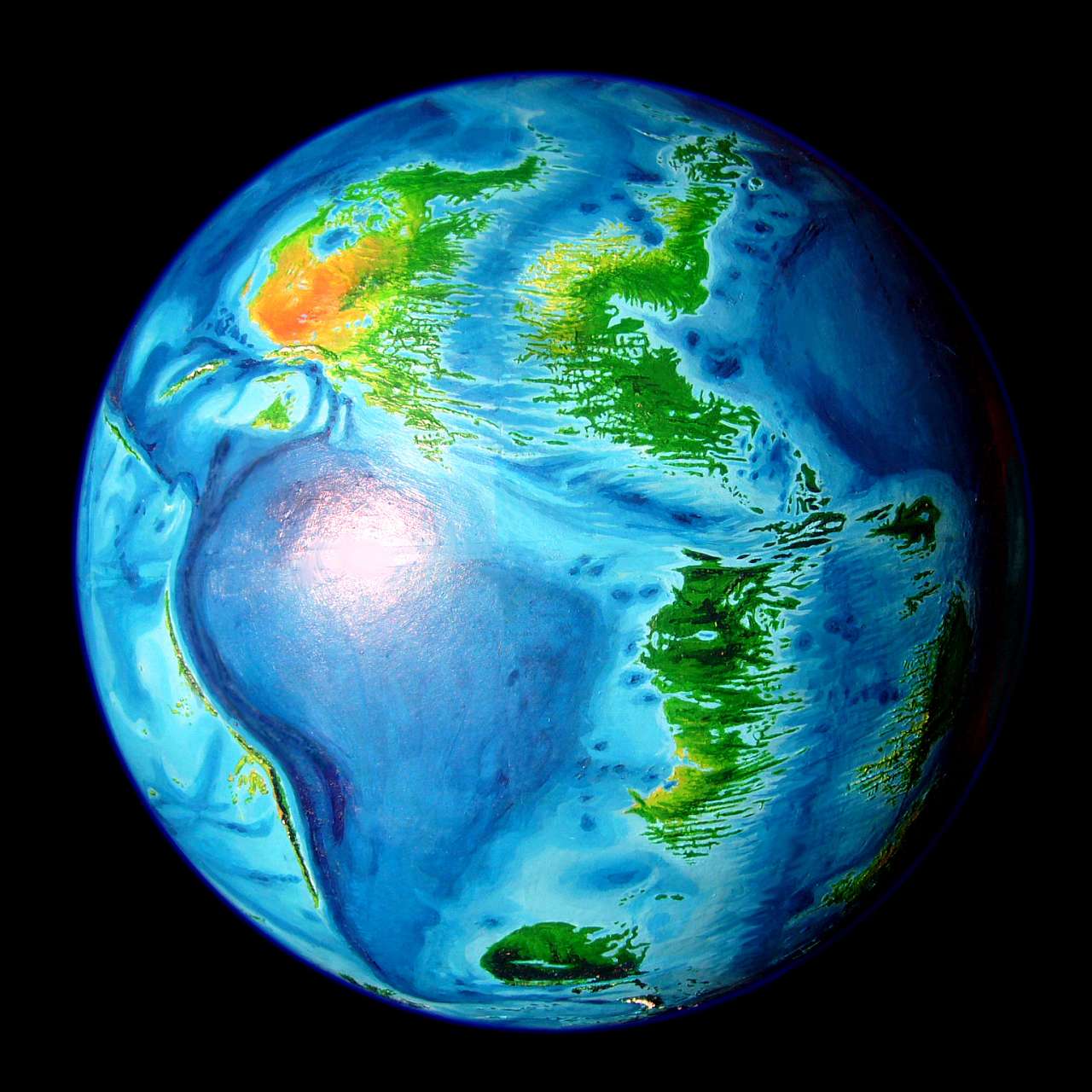
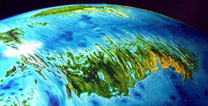
Abyssia's upside-down equivalent of our Atlantic Basin is a long S-shaped platform called the Atlantis Rise, split down the middle not by a ridge but a rift--the narrow Atlantic Sea. On the platform are six small continents and a pair of archipelagos. Atlantis and Azorea in the north and Argentia and Tristania in the far south all have their own pages; here I'll cover the tangle in the middle, from the equator to about 30 south.
The equatorial zone is a complex, indeed shattered region: the Leone Islands. Here the Atlantis Rift bends sharply; numerous fracture zones create long slender mountainous islands--La Romanche, straddling the equator, rises to 3000 meters (10,000'). Yet just offshore are deep "fjords"--long straight sounds, often cliffwalled, up to several kilometers deep.
To the east is Guinea, a calmer land further from the violence of the rift. Here the ridges rise only 1300 meters (4300').
Further east is another violent feature, Cameroon Canyon, where blue holes suck the crust relentlessly inward like slow singularities. Cameroon Hole, at the corner of the main map, is 9 km deep (6 miles). On Earth, a hotspot has formed a great chain of volcanoes and seamounts, rivaling Hawaii.
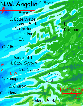
To the south are twin continents, Pernambuco in the west and Angolia in the east. I call them continents because they're solid, continuous chunks of land with real interiors, unlike most of the spidery islands Abyssia features. But together they are still just 2/3 the size of Australia. Twin Greenlands? In size and shape, not a bad analogy.
But not climate. These are tropical lands. Only the mountains of far southern Pernambuco ever see snow, and only rarely; they're no higher than the hills of Guinea. In fact, not one peak on either continent, tropical or not, reaches even a mile high. Lower than Australia.
Low doesn't always mean gentle. This is young, raw crust full of scarps, ridges and canyons--it's just that most are still underwater. But not all. The shores facing the Atlantis Rift (Pernambuco's east coast, and Angolia's west) are jagged fracture zones--an endless procession of cliffy heads, deep sounds, islands and shoals, mostly perpendicular to the deep rift zone offshore separating the twin continents.
Introduction - Coastlines & Names - Leone - Guinea - Pernambuco - Angolia
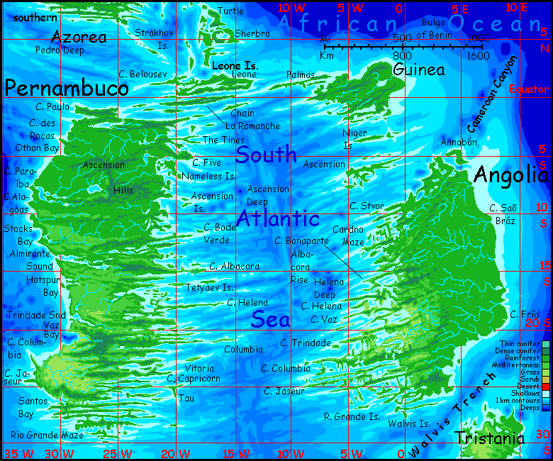
Much of the abyss, even today, isn't well mapped, and the South Atlantic has had way less shipping and study than the north. Some areas, notably the Brazilian coast and the rift zone around St Helena and Ascension Islands have good resolution and named features; other regions are so-so. Still, the Atlantic Rift between the twin continents has bold relief, so I'm pretty confident of the coastlines and landforms. But names are in short supply and sometimes conflict. In this area, Atlantean features can be named for an Earth feature a long way off. Our islets and seamounts were found and named long before nearby abyssal features like fracture zones, so these zones often get named for islands, reefs and seamounts. Since these zones can stretch 2-3000 kilometers, an Earth island's name may crop up on an Abyssian peninsula or bay a whole continent away. Many maps ignore these lesser fracture zones, but I couldn't--the only source of names for many South Atlantean regions. So don't be surprised at some strange displacements--particularly the application of Brazilian seamount names to Angolia's coast far to the east. My dislocations are based on (though they can't exactly follow) nomenclature on Earth. Judgment calls, yes, some of them desperate--but the names are not arbitrary, any more than the landforms are.
There are exceptions. A few regions, mostly abyssal plains, totally lack Earth names for their details. In northeast Pernambuco, the Tines are flat description of this forked fracture-cape, and the Nameless Islands (two sets!) are sheer frustration. Cape Five though, has a certain legitimacy: the nearby One South Islands are the Abyssian version of an Earthly trough named the One South Fracture Zone. Not very poetic, but authentic.
Southern Guinea (Two South Peninsula, etc.) and southeast Pernambuco (Cape Capricorn, Tau Island) were equally name-destitute.
Introduction - Coastlines & Names - The Leone Islands - Guinea - Pernambuco - Angolia
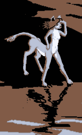
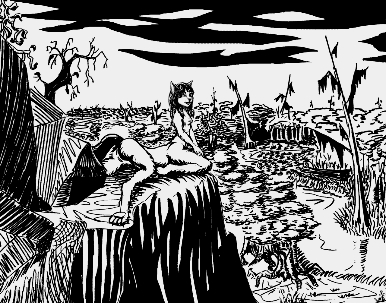
Wet feet: not a leptaur thing |
Leptaur & lagoon, Blue Pig I.; faux 4-color print (2017) by Wayan after Pomponio's Beach (1979), woodblock print by Tom Killion |
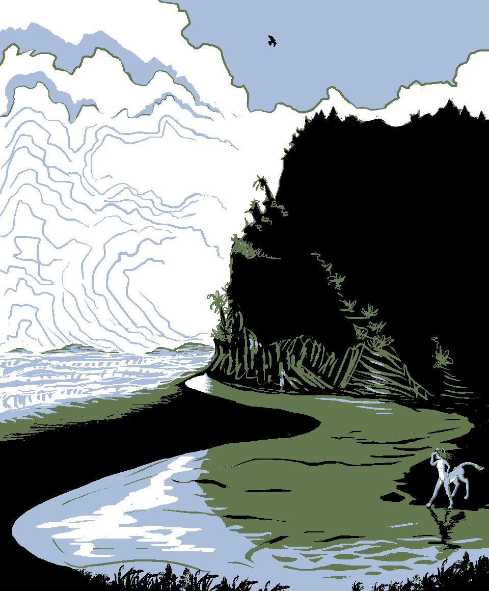
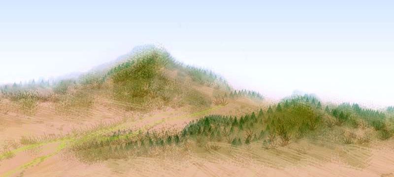
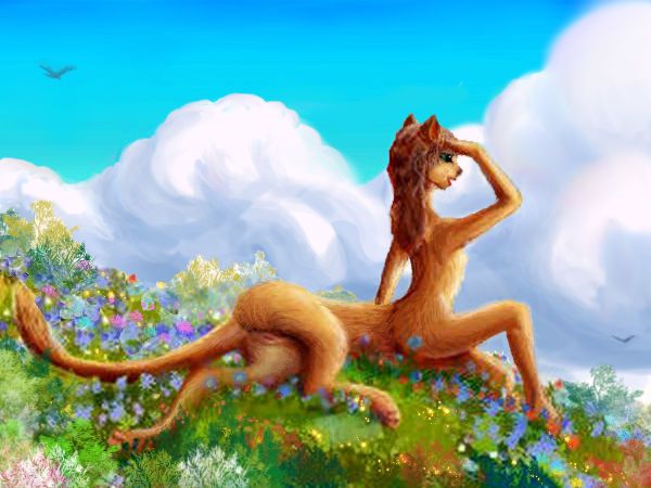
The rainforested Leone Islands are the equivalent of our Sierra Leone Abyssal Plain, off West Africa. The name "Leone" makes some biological sense, too, as the most common people you'll see (in port towns, at least) are leptaurs, leopard-sized centauroid omnivorous cats native to Atlantis to the north. They evolved on savanna and prefer open ground to this rainy, muggy archipelago. Still, the Atlantis Rise continues south past the equator, supporting an armada of islands and mini-continents all the way to Pacifica; a trade highway that's lured their species--at least the restless minority willing to go to sea--into the broadest distribution of any mammal on Abyssia.
So feline shopkeepers, dockworkers and sailors fill the ports, and a few of them, over time, grow to appreciate the lush scenery, the rainbows and changing light, the flowers and fruit-laden vines even in towns; they accept the regular rains (dripping off your whiskers, confusing your proprioception--ugh!) as the price. Every species has its tropical dropouts, right?
Sierra isn't just named as a generic reminder of the semantic origin of the archipelago, either; it really does have a Sierra. In fact, the mountains along its south coast are the highest in the whole northern group. That's still only about 1200 m (4000'). But impressive for the this low region where the Tectonic Gnomes (don't ask. Oh well, too late. Small centauroid troglodytes with warthog tusks (scary!), leathery skin not fur (uncanny!), and rotten tempers, causing quakes and tsunamis--but also uplifting islands. Yes, it's weird folklore. Leptaurs are sailors, and sailors always have weird folklore. My Terran readers should think twice before sneering, given that many people in advanced Terran cultures blame earthquakes on giant itchy catfish and gay people who get married.)
Anyway, Leone, this non-continental flooded stretch, means, to a leptaur, that the union crew of Tectonic Gnomes building Atlantis took a little unauthorized nap. The place needs, to the leptaur mind, shoring up. Literal shoring up.
Don't blame me, leptaurs, or nonexistent gnomes for those islands named Cindy and Blue Pig and so on. Whatever human researcher sounded this area was just whimsical about naming seamounts.
Oh well, I prefer names of friends (and pigs) to the earnestness corporate butt-kissing that led a National Geographic expedition to the West Antarctic wilderness to name a line of jagged 4000-meter peaks... the Executive Committee Range! Now there's a name full of polar poetry...
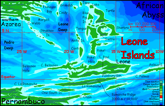
The south, dominated by Leone and La Romanche, is more rugged. At least three fracture zones cross the region, east to west; the ridges on La Romanche reach about 3000 m (10,000). This highland is tiny, but fascinating. A sky-island generally above the equatorial sea of cloud, it's a sunny sliver of rocky alpine meadows full of weird plants like Hawaii's silversword. Not a place you'd expect to find in the middle of this tropical rainforest. But altitude will do that.
Leone, though much larger, is lower; its highest peaks are perhaps 1500 m (5000').
Huge Lake Paul teems with cichlid fish and freshwater dolphins.
To the southwest of La Romanche rise the One South Islands. Three long islands, each a Romanche in miniature, the One Souths are different in just one way: their summit ridges top out at just 1400 m (4600')--in the clouds, not above them. The dripping forests of these summits never see the sun. Or moon, or stars--black nights, gray and silver days.
The One Souths are within sight--if you could see anything--of the mainland of Pernambuco, the biggest continent on the southern Atlantis Rise.
To the east, Las Palmas Island, only 30 km wide but 600 long, is a similar bridge to...
Introduction - Coastlines & Names - Leone - Guinea and its Satellites - Pernambuco - Angolia
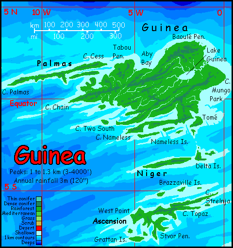
All I've said about the Leone group is true of Guinea, except that the land is gentler; few mountains over 1200 m (4000'). No surprise--we're further from the violence of the Rift.
At least above water. This stretch of the Atlantis Rise sags mostly below sea level; the fracturing may just be better hidden. Certainly the Niger and Ascension Islands look classically fractal--all peninsulas and sounds. But eastern Guinea's coastal plains and low hills are a different pattern, one we'll see more of on Pernambuco and Angolia--inverted abyssal plains.
And inverting a plain gets you... a plain.
The terrain may be gentler, even dull... but not the climate. Guinea straddles the equator, in the heart of the rainbelt. Storms year round, some quite violent; after all, they have thousands of miles to build intensity as they cross the African Ocean, bigger and perhaps a bit warmer than our hurricane-spawning Atlantic.
Those heavy rains nourish tall tropical forests not so different from the those mantling Nigeria's coast. Before farming and cities and oil, I mean.
The Ascension Archipelago, the furthest south, is marginally drier--the rains ease off a bit in winter (June to August).
From Cape Strelnja ("streln-ya"), if you sail or fly southeast 240 km (150 mi) you'll make landfall on the northern tip of Angolia. This is the widest such gap in the region--elsewhere you can always see the next land on the horizon; small boats or even rafts might be adequate. But this strait takes deepwater skills--or wings. It's comparable to the strait between Timor and Australia.
Still, such barriers may not matter as much on Abyssia, where birds dominate. Though I suspect most of the intelligent ones will be big and flightless. The dominant avian of the continent to the north on the Atlantis Rise, Azorea, is the diatryma, big, fierce and (as a result) not just flightless but solid-boned. Unable to swim--they just sink--diatrymas are unenthusiastic sailors. They are only here in modest numbers, as relatively recent immigrants who took passage on trade ships crewed by leptaurs, who can swim, and explored Guinea a full millenium earlier than the diatryma--but barely settled it. Too damp for them. Significant numbers of leptaurs do live in port towns and less rainy zones all down the Atlantis Rise--but Guinea isn't popular.
A third intelligent species arose not too far away, in southern Angolia--but rheas are, like leptaurs, savanna people at heart; they find the Guinean climate clammy and the dense Guinea jungles claustrophic--something's going to jump out and bite you, and you can't run with smacking into one of these damn trees. And rheas are built to run.
The result? Despite three intelligent species in the area, the inland rainforests of Guinea are quite thinly populated--quite as much a backwater (and a swampy one too) as similar rainforests are on Earth.
Here are sketches of two Central Atlantean avians--but the truth is, neither one is Guinean. They were both sketched on bigger, drier, less boggy (and buggy) Pernambuco, to the south. I just couldn't sketch very much on Guinea. Too many damn bugs!
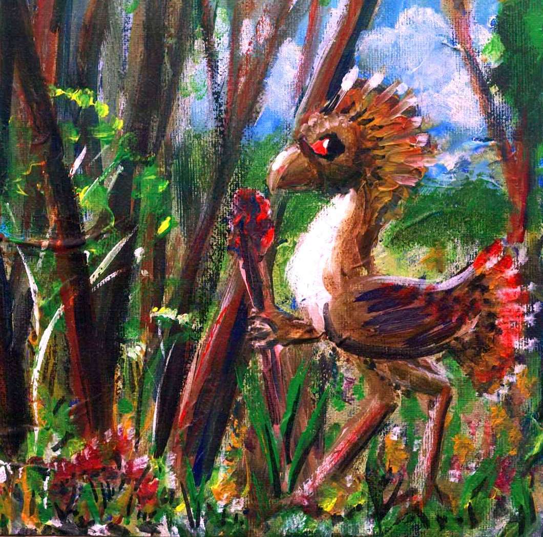
Titanis or Diatryma, Hotspur Bay, W. Pernambuco |
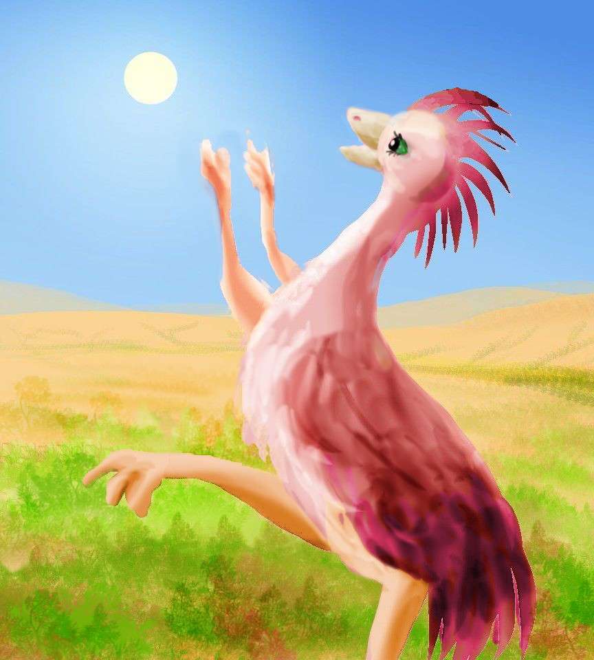
Rhea's sundance, Columbia Hills, S. Pernambuco |
Introduction - Coastlines & Names - Leone - - Guinea - Pernambuco - Angolia
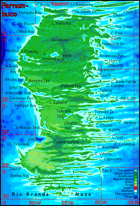
Pernambuco is the largest continent on the southern Atlantis Rise, but that's not saying much. Australia's over twice as big. Still, Pernambuco's biomass outweighs all Australia--and probably even western Europe's. It's a lush Amazonian rainforest--not unbroken, especially in the far south, but yet another Abyssian land too low, small and maritime to have true deserts.
Aside from generous rainfall, how's the weather? Mild compared to Earth's Atlantic coasts--summers do see tropical storms, but never true Caribbean hurricanes: this Atlantic Sea is narrower than our ocean, so storm-spirals have just a few days of warm water to feed on before they hit land and start to starve. It takes elbow room to brew a good hurricane--same as it takes a long "fetch" to generate big waves (there's a reason most great surfing's in the Pacific). And this shrunken and nearly landlocked Alantic, barely a third the width of ours, simply lacks the fetch for full-on hurricanes.
Not that the Pernambucans are crying over that.
THE NORTH
The north is steamy--like the Orinoco. But there are cooler highlands atop spectacular cliffs. What's it like up there? Roraima? Lots of equivalents of Angel Falls, that's for sure. The mountains of Cape Chain reach 1700 m (5600')--low by Terran standards, but the highest on Pernambuco. Like the One South Islands, I suspect these peaks are wreathed in perpetual mist. Or drizzle.
Don't visit unless you like mold.
THE EAST COAST
Ragged. Unbelievably ragged. Fractal. Beautiful.
The northeast is frustrating for a cartographer--these fracture zones aren't named. The Tines are a forked peninsula 320 km (200 mi) long; their name is flat cartographic description. But Cape Five has a certain legitimacy: remember the One South Islands, the Abyssian version of an Earthly trough named the One South Fracture Zone. Not very poetic, but authentic.
The Nameless Islands. Or maybe the Numberless Islands, since I'm not sure how many there are; their coastlines are low and uncertain compared to the usual bold scarps further south.
In general, this northeast coast looks gentler and less fractal than the south-central or far southeast. I find that suspicious--it may just have been mapped less thoroughly.
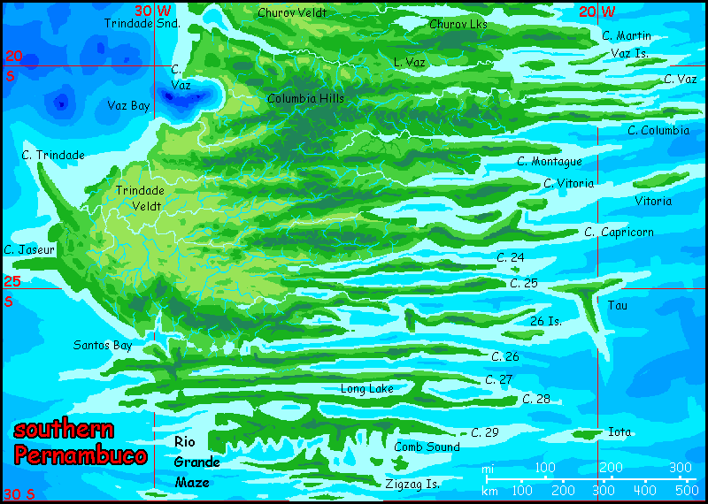
The central and south coast is unusual even for fracture zones--on most of Abyssia, they're chaotic interference patterns of ridges at right angles. But here, straight capes and fjords up to 600 km long alternate neatly, all packed in tightly as the teeth of a comb. Only in the far south, around Tau Island and the Rio Grande Maze, do you see many large points and sounds at right angles to the main fractures.
But this may change. As newer soundings reveal more fractal detail, I bet this coast will only lengthen. Even now, in my crude simple mapping, this fractal shore is ten times longer than the straight beaches of the west--from Cape Helena to the Rio Grande Maze, I estimate over 18,000 km (nearly 12,000 mi).
That's a lot of clambeds.
THE WEST COAST
An utter contrast to the east--a simple, straight coast except for a few lake-chains, it looks like a big green carpet--occasionally rumpled, but mostly flat. The hills rarely reach 1.2 km (4000'); most are much lower. There is some quite savage vertical relief here, but it's all invisible: many of the lakes dotting this placid-looking forest are miles deep, deeper than any on Earth: pitlakes, flooded holes where crust is being sucked down into the mantle--inversions of Earth's volcanic seamounts. Lake Fleming in the northwest is over 2000 m (6600') deep. Lake Hotspur is nearly 4350 m (14,250'), almost triple Earth's deepest.
Such pits often have hot vents emitting carbon dioxide, sulfur and other minerals feeding strange deepwater life-colonies like our mid-oceanic vent communities. But the shores of a pitlake can be chancy for land life--now and then a CO2 cloud will asphyxiate all animal life nearby.
As if the plant life cares! It's verdant rainforest, even around the deadliest pitlakes.
Carbon dioxide is heavier than air, and stays low. As a result, villages near pitlakes and the swamps often fringing them are generally on bluffs not down by the water. Not a perfect solution, but most of Pernambuco is quite rainy, so cisterns can collect plenty of drinking water up on the bluffs. A longer walk to the lake to fish isn't a high price to pay for partial safety against an invisible, indetectable killer.
Besides, the view is better.
Down at least as far as Lake Fleming and Cape Alagoas, and maybe as far as the Moreira Lakes around 12° south, the rainforest canopy is essentially unbroken except for lakes and swamps. But beyond Almirante Sound and the Bode Verde Hills, the rains come mostly in summer; winters are mild and sunny. The forest opens up a little. Past Trindade Sound, at 19° south, open meadows occasionally appear, mostly on northwest-facing slopes of hills and ridges, where the afternoon sun dries the soil.
THE SOUTH
In the far southwest, savanna! Most storms here roll in from the east--inland--and the central hills, though low, take most of the brunt. Open forest on the hills, but the plains are grassland. It's still not arid, though; trees dot the prairie and line the slow rivers.
Leptaur in savanna heaven, Cape Jaseur, southwest Pernambuco |
Trindade Savanna is the largest on the central Atlantis Rise, and supports great herds of grazing... centaurs? Half-ton rheas or ostriches? (With hands, of course!) If savanna is ideal for the evolution of intelligence, this is the most likely cradle in this region. Even if no indigenous species achieves intelligence, the population of settlers from nearby lands will peak in this region; even that notoriously fussy species humans would find it pleasant.
I've noted already that most of this Central Atlantean Rise is really too rainy, buggy and damp for leptaurs. But much of southern and western Pernambuco is, at least during the dry season, close to leptaur paradise. Sunny, flowers, quite a lot of fruit (remember, they're omnivores not obligate carnivores) and a lot of strong, resinous, rather Mediterranean herbs--for a leptaur, a landscape's beauty is as much about scent as sight.
No such savannas in the southeast, and especially the far south around the Rio Grande Maze. Unbroken forest here: much rainier. Also cooler; with no storm-barrier to the south, winter rains can sweep in from the Rio Grande Islands and chilly Argentia. Never snow, but occasional freezes have been recorded. We're not in Rio anymore. Atlanta, maybe. Or Okinawa...
Those endless promontories of the Rio Grande Maze with names like Cape 24, Cape 25, and Cape 26 aren't part of a sequence running north to south; they indicate the latitude of each peninsular tip (roughly). They really are about a degree apart, regular as a heartbeat. Such names have a (faint) justification; in our central Atlantic some fracture zones are just labeled with their latitude--but around the equator, not here. But with no names at all for these features in our world, I coined these in desperation.
Introduction - Coastlines & Names - Leone - Guinea - Pernambuco - Angolia
THE NORTH
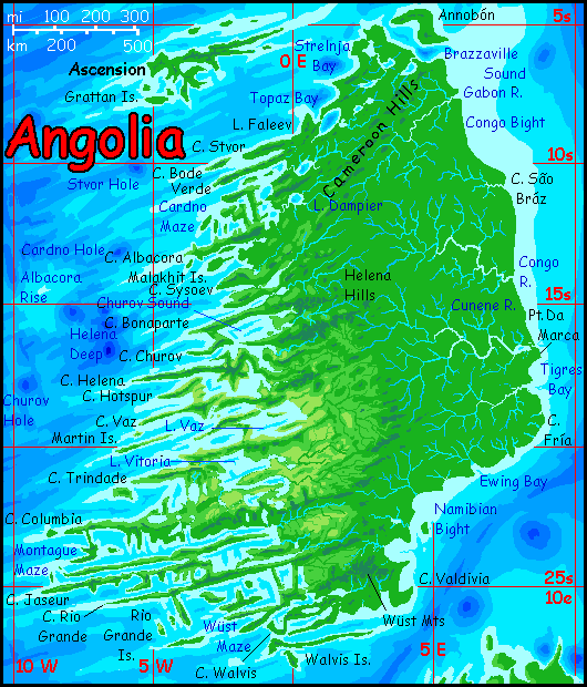
Northern Angolia is atypical for the twin continents. Offshore lies Cameroon Canyon and its associated blue holes, a huge trough; though diminished, trough and holes extend 1000 km (625 mi) diagonally across the north. The most noticeable feature is the chain of deep lakes and bays from Brazzaville Sound to Lake Dampier. When I say deep I mean deep. Lake Baikal, deepest on Earth, is just 1500 meters (5000'); in North America, only a few lakes--Tahoe, Crater, Great Slave--reach even 500 meters. Lake Dampier is deeper than Baikal, and Lake Faleev is twice that, more than 3000 m deep (10,000'). Strelnja and Topaz Bays are more like 4000 (13,000'). These pits, the equivalents of our volcanoes, have hot, active bottoms heating the deep water so it rises in thermal thunderheads muscling aside surface layers. No stratification here, but a convection pattern seen on Earth only in Lake Baikal--and of course in boiling pots.
Some of these cauldrons are poisonous. Carbon dioxide and sulfur taint many of these lakes (or enrich them, if you're that sort of life-form.)
Still, the region is lush. Lake Faleev may burp CO2 clouds now and then, killing animal life around its shores, but the jungle does just fine.
Less instantly recognizable at this resolution, but larger, is the Cameroon Valley--or Cameroon Slash, as it's locally called, for it's not a river-cut feature but a long straight knife-slash--and the Cameroon Hills just east of it. The hills are a rebound feature. All the crust missing in those holes causes the area as a whole to bulge in response. The same phenomenon (upside down of course) can be seen even more plainly off Hawaii, where the sea floor around those massive volcanoes has sagged up to a kilometer under their immense weight.
THE EAST
The entire east coast, from Brazzaville Sound to Cape Valdivia, is a great rainforested plain. Well, in the south, in the Tigres, Ewing or Namib Basins, it's drier; only half the rain you see in the north around the Gabon River (3 meters or 120"). But even 150 cm (60") sustains lush forest. It's heaviest in summer, when hurricanes sweep in off the African Ocean, wider than our Atlantic. If not the Amazon, think Gulf of Mexico.
THE WEST
The west coast is much more complex in both geography and climate.
Imagine it's a musical chord written in stone. The bass note is a regular series of fracture zones--the borders between parts of the Atlantis Rift spreading outward at different speeds. These fractures form parallel ridges and valleys, straight and often cliff-walled. On this stretch of Atlantis these major fractures average 5-600 km apart (3-400 mi), reaching up to 3000 km from the Rift.
Unlike Earthly strike-slip faults like our San Andreas, which generally look like a straight knife-gash on the land, there are smaller harmonics: several lesser fractures between the big ones. Lesser still, just 50-160 km long (30-100 mi), are endless ridges and basins at right angles to all this, parallel to the Rift itself. As the spreading crust forces itself outward it crumples under pressure. The result is a landscape looking artificial to the Terran eye. Just too many right angles for Nature! A drowned city, an ancient watermaze, a sewer system? But the scale is wrong. Beyond dinosaurian! Next to this, city planning by Godzilla would still look like dollhouses. And these giant grids cover millions of square kilometers of Abyssia--though most of it is still underwater. Only the fringes rise above the sea.
The technical name, tessera, means any endlessly repeated feature in a regular pattern, from street-grid to honeycomb. Curiously, the term was coined to describe parts of Venus, even though Earth has just as much tesserated terrain--just as much as Abyssia, of course, as they're the same world just inverted. But our tesserae are all drowned deep--even harder to study (and worse mapped) than Venus's surface, swathed in sulfuric acid clouds (and equally smothered in Mars-biased neglect. Our nearest neighbor! Shouldn't you study your evil twin, to know what not to do? Say, about CO2?)
The Terran tesserae you've never heard of are proof, if you doubted, that the abyssal Earth I'm highlighting here really is an alien world.
To us at least.
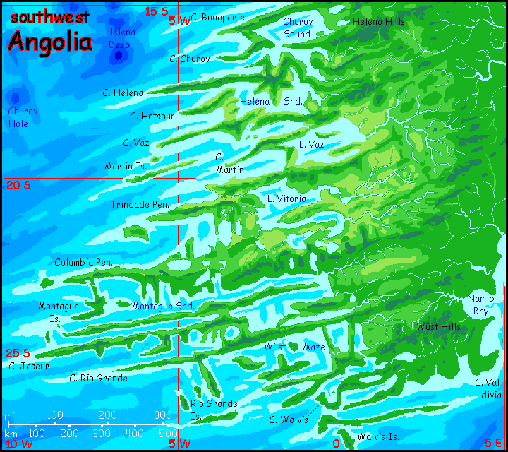
Cardno Maze, on the northwest coast, shows the tesser-ish result of these right-angled forces. Though probably oversimplified; every new map of benthic terrain shows still more fractal madness. And they're not always right-angled: consider Cape Helena or Cape Vaz to the south.
Past 15° south the land grows slowly drier--with exceptions. On the outer isles and capes, west coasts are green and wooded, for they face storms off the Atlantic Sea. But such fronts are relatively gentle and fade inland. Here, most rain comes from summer storms making it over the low hills from the east. And west-facing slopes face full sun in the hot afternoons; they dry out more. East slopes have evener temperatures; easier on seedlings. So inland ridges are often open woods or brush or even grassland on their hotter north and west faces; wooded on the east. It's not just a geographic maze but a maze of microclimates.
Not including desert. Although Angolia straddles the desert-prone latitudes of 20-30° south, it's no Australia; that's an Amazonian rainforest beyond the Helena Hills, not the Great Sandy Desert! Nor are these hills the Andes--not even the Great Dividing Range or the Appalachians. Low and broken, they let storms through from the wide African Ocean.
Still, as we creep south toward 30°, the mainland opens into dry savanna. Trees stop being the story and become mere punctuation dotting these plains and lining the streams. But the hills still snag enough rain for open woods and groves.
All in all, it makes for big, dramatic views.

On Earth, the seamounts around St. Helena have been mapped more thoroughly than much of the South Atlantic. But once we're south of Helena Deep and its satellite holes, names grow scant; I've adapted names from minor fracture zones themselves named for seamounts far to the west.
Nor am I as confident of detail down south; my only certainty's that places like Wüst Maze will turn out to be even more complex than I've shown. Remember even the blowup maps are still an overview; those peninsulas and sounds are up to 1000 km long!
The Tropic of Capricorn marks a subtle boundary. In higher latitudes, summer storms slowly decline in strength, just as on Earth; the sun doesn't stand directly overhead. Less energy to fuel hurricanes. However, in these same latitudes, from 23-30° south, Angolia narrows and then sags into the sea. Summer storms are a little weaker and less frequent, but now they roll in unimpeded. And winter rains sweep in from the south over a thousand miles of sea. Nourished by two oceans, the Wüst Maze and Walvis Islands are nearly as green as Cuba.

Abyssia's homepage - map - peoples - regional tours - names
LISTS AND LINKS: More worlds? Planetocopia! - dreams of other worlds - ecology - climate change - evolution - natural disasters - terraforming - sculptures and 3D art -
World Dream Bank homepage - Art gallery - New stuff - Introductory sampler, best dreams, best art - On dreamwork - Books
Indexes: Subject - Author - Date - Names - Places - Art media/styles
Titles: A - B - C - D - E - F - G - H - IJ - KL - M - NO - PQ - R - Sa-Sk - Sl-Sz - T - UV - WXYZ
Email: wdreamb@yahoo.com - Catalog of art, books, CDs - Behind the Curtain: FAQs, bio, site map - Kindred sites